Chris Lambert is a field geologist for the Council for Geosciences. He has worked in several countries throughout Africa. You can read more about Chris’ research here.
As a field geologist for the Council for Geoscience (Geological Survey of South Africa) I have been privileged, I guess as many geologists tend to be, at least in my view, to work and explore some of the most picturesque places around the globe. In what is to be my first attempt at sharing in one of these adventures I thought it may be appropriate to start at the bottom, the real bottom, a place more than 100 m below sea-level, a place where mantle meets the surface of the earth. The Afar Depression or Danakil Depression in northern Ethiopia is one of the lowest land surfaces in Africa and is host to one of the few remaining active magma crater lakes in the world and was the destination of one of my very first geological adventures.
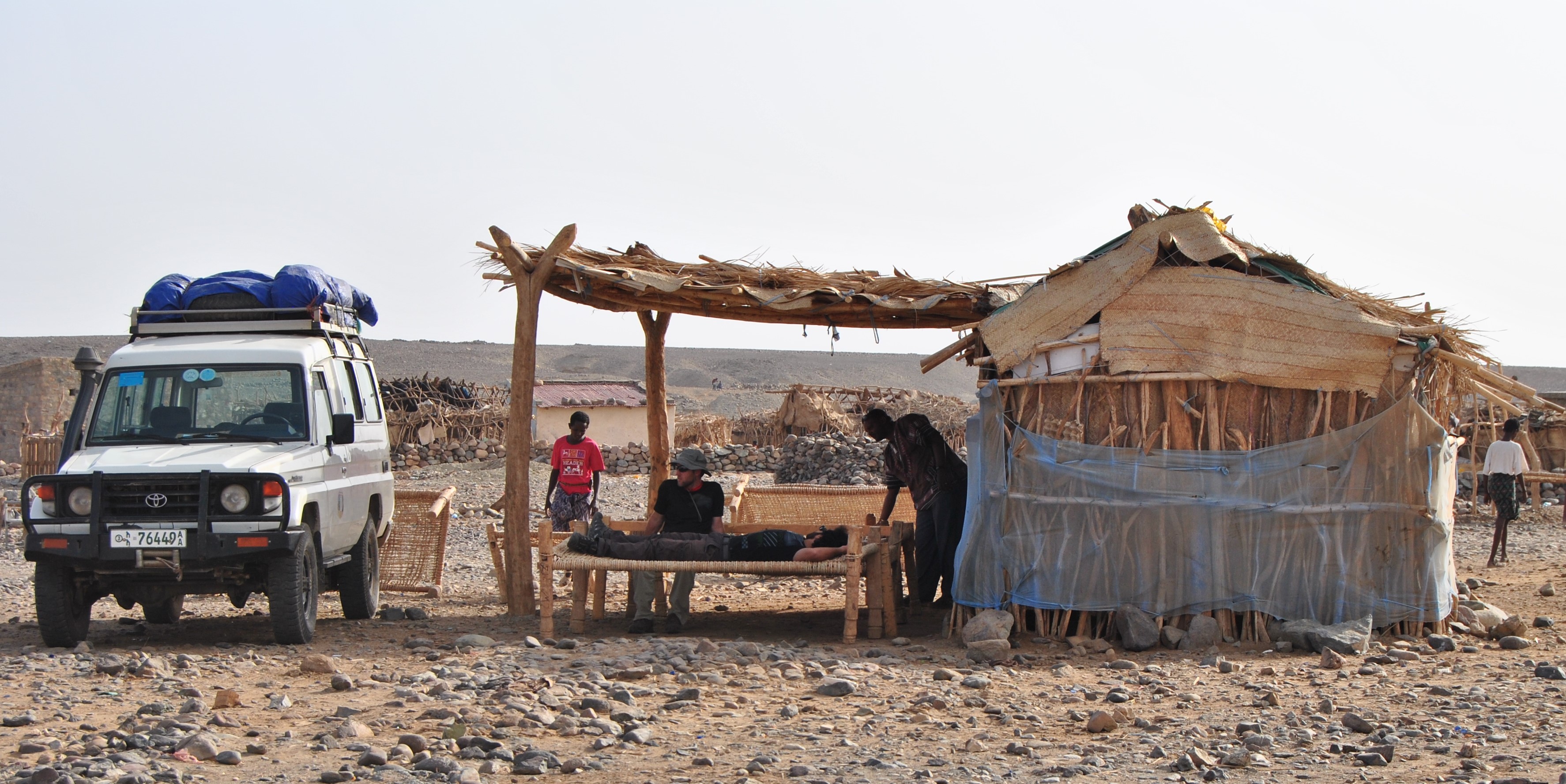
Our first stop in the Danakil was our basecamp at Berhale village where we slept on weaved beds in the shade of the huts that were occupied by the guards and guides.
After attending the CAG 24 conference in January 2013, myself and two colleagues seized the opportunity to venture into the Afar. The region is situated near the Eritrea and Ethiopia boarder in the Horn of Africa where a tectonic triple-rift junction is actively opening up the Red Sea, the East African Rift and the Gulf of Aden. This salt crusted desert hosts the Dallol sulphur springs and the Erta Ale and Dabbahu volcanoes. The area is also considered as the cradle of hominids after the discovery of the Lucy Australopithecus fossil by Donald Johanson and his team in 1974. If it were not for the extreme logistical (at that time) difficulties and cost of visiting the area, I am sure it would be one of the most frequented geological sites in the world but I guess this is the reason we can call it a true adventure.
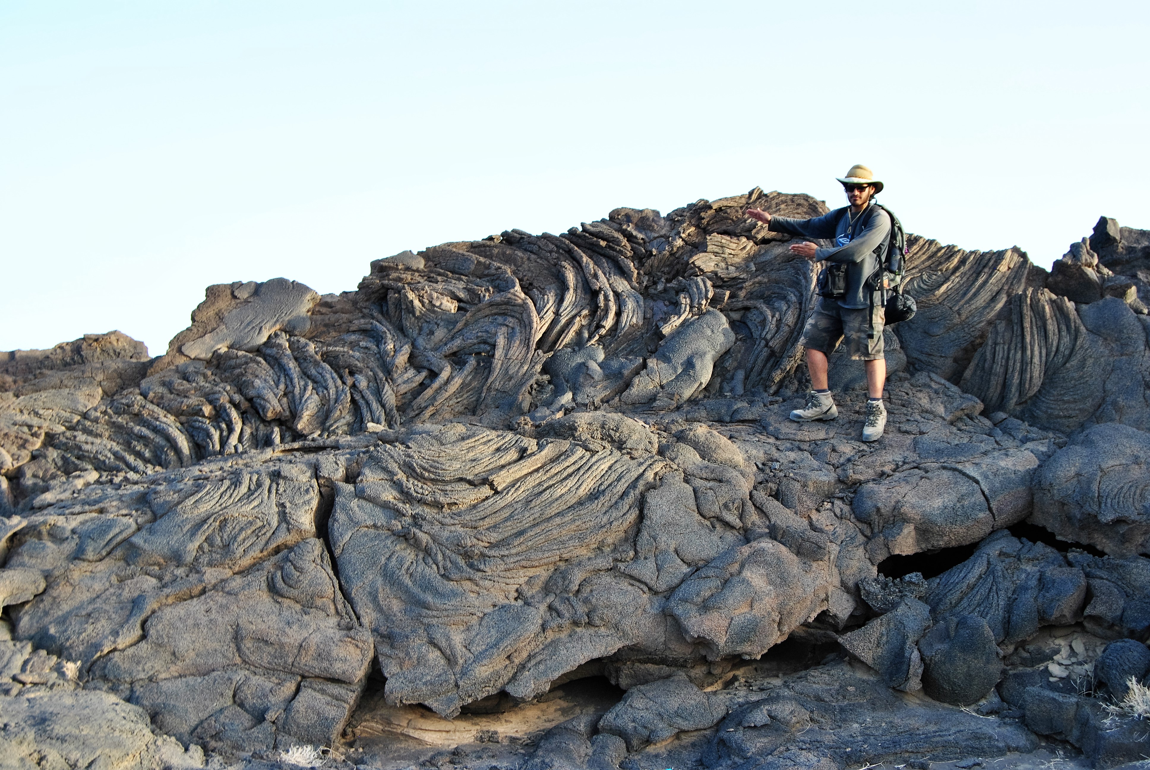
As we walked up Erte Ale volcano beautiful structures of now crystallised, viscous lava flows dominate the slopes of the basaltic volcano.
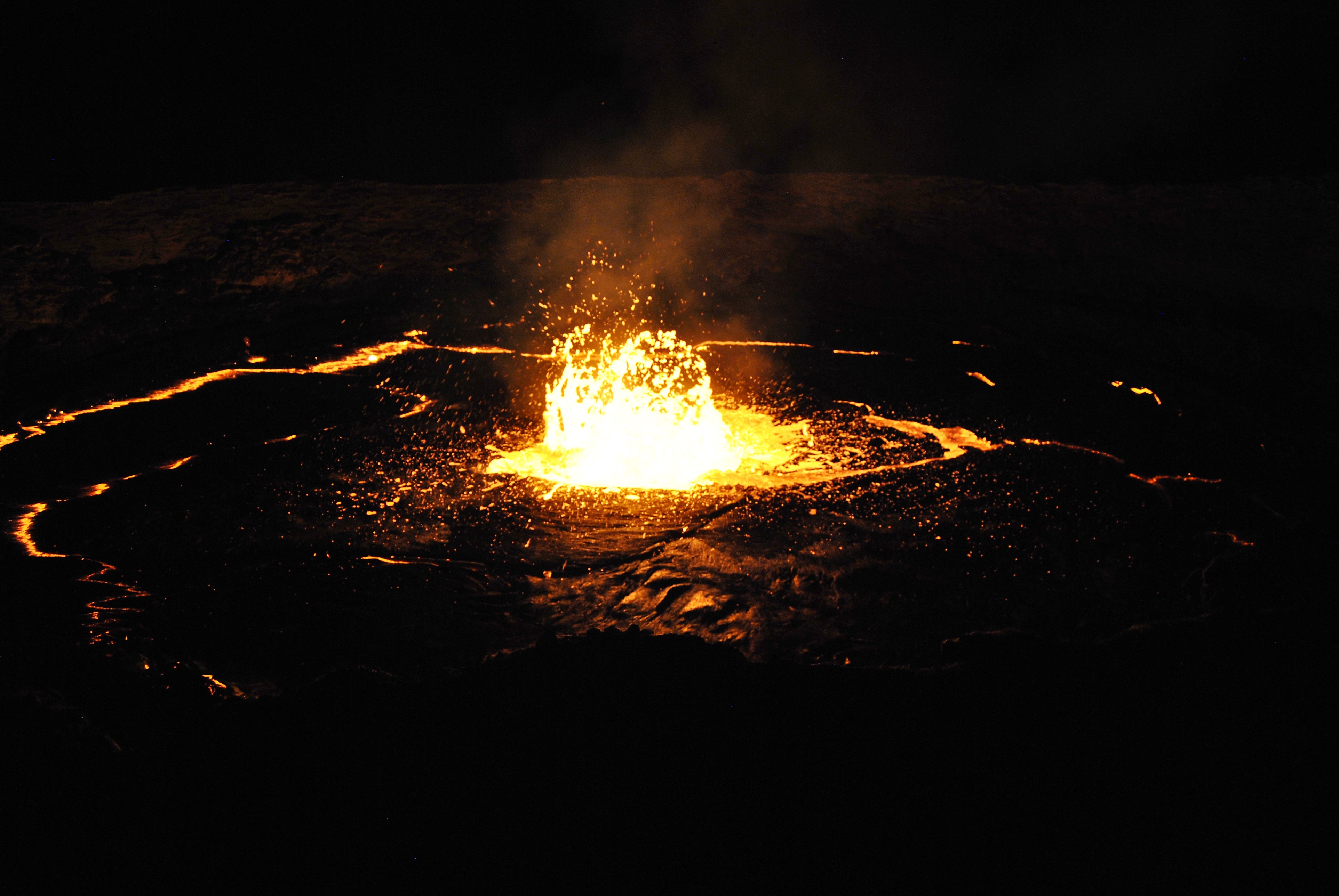
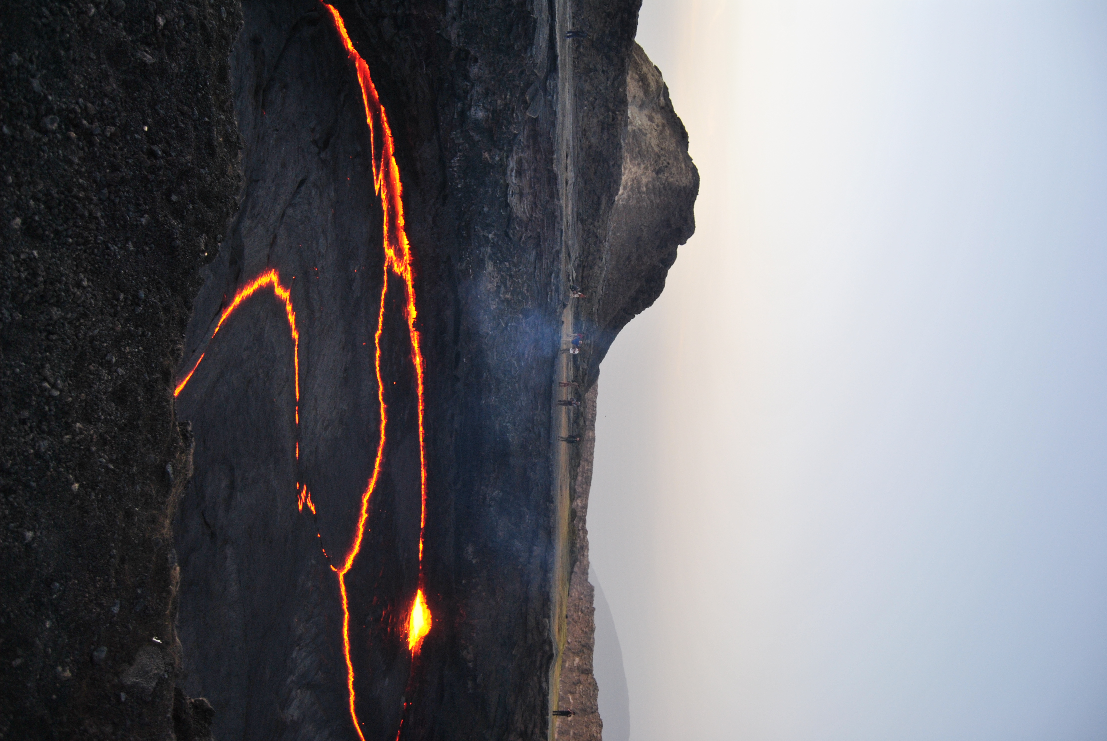
The lava lake on top of Erte Ale commonly displays plumes of magma bursting through the crust like layer that forms on the surface of the lake.
After endless consultations with travel agencies in Addis, who are intent on sending multiple vehicles, cooks, drivers and armed guards with our company of only three people, we were eventually able to negotiate our way past the unnecessary additions. A short flight later and the three of us climbed into the back of a Landcruiser 4×4 manned by Jomo, our multipurpose negotiator/translator/guide/driver as we headed from Makele to the Danakil.
As three young geologists on a budget and being from South Africa where there is a general awareness of shady-deals, we were probably naïve to how things really work in the rest of Africa but it became apparent that in Ethiopia, especially anywhere there might be tourists, you will be subjected a variety of “facilitation-fees” for everything from overpriced permits, to hiring unnecessary guides, toilet “facilities” and even shaded areas but nonetheless we were determined to be part of the privileged few who are able to gaze upon the bubbling mantle at Erta Ale. Before descending the 1000 m into the depression we came across our first “facilitation” through the compulsory hiring of a regional-guide who we can only remember as Mr. ‘Red-Beard’ in addition to two guards armed with AK-47 rifles. This escort was said to be due to the unrest along the Eritrea border where there were unfortunate deaths a few years prior. I do however doubt, or rather hope, that there were any bullets in the guns by the way they were handled in the back of the 4×4 as we bounced down the bumpy track of the escarpment. After a gruelling 6 hours of rough road and inadvertent rifle pointing we eventually arrived at the base-camp near the Berhale village only to find out we had unknowingly become the local contraband couriers as about 12 bags of Khat (Catha edulis), a local hallucinogenic plant native to the Horn of Africa, was pulled out of our vehicle by the locals.
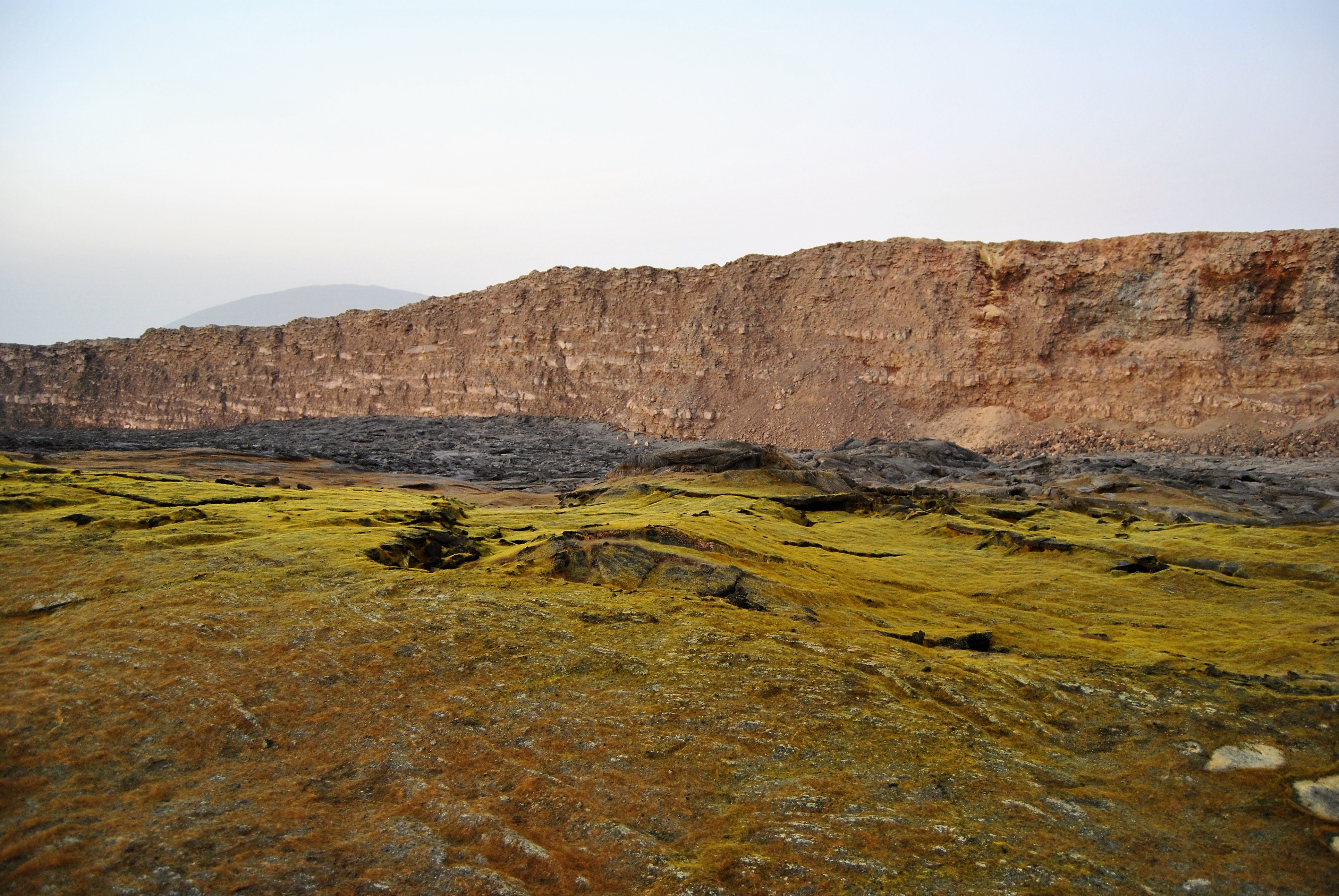
In the daylight the sulphur glass crystals blanket the caldera of the Erte Ale formed by the crystallization of the sulphuric gas emitted from the volcano.
We anticipated that we were to summit Erta Ale early the next day but with day time temperatures of nearly 50oC before mid-day we were informed it would take place during the cooler 25oC -30oC evening hours. So the following morning we set off across a featureless (which lends itself to a certain kind of beauty) salt encrusted desert floor to the assuredly ‘near-by’ village to “facilitate” additional permits. Four hours later we had our “volcano-permit” and negotiated our way out of adding four extra guards to our party and settled on just the one new guard who was to act as our now more “local-guide” in addition to Mr. Red-Beard. The following two or so hours driving across the desert were highly entertaining as our the guides and guards argued about the best route to take to the military base at the base of the Erta Ale volcano despite the unidirectional sets of existing tracks to the only site visited by vehicles.
The edge of Erta Ale
After arriving at the military base we were careful not to encroach on any of the huts or the shade thereof as we had by now caught on to the money making scenarios of the locals and decided to circle in the shade of the car instead. Just before dusk we prepared some ‘western’ pasta for our compulsory companions for which they were joyfully grateful although I think the sight of three foreigners cooking for them using one pot on an open fire in the sweltering heat was what gained us a little respect and a lot of laughs. At dusk, geared with tents, cameras and headlights, we started the approximate 20 km hike up the basaltic slopes of Erta Ale. Erta Ale means “smoking mountain” in the local language and forms a 613 m high shield volcano and hosts the longest existing lava lake, sometimes referred to as “the gateway to Hell” and has apparently been consistently bubbling since the early twentieth century. The last major eruption was on September 2005 but eruptions and over-flows have been recorded as recently as 2009. As a geologist the hike probably takes twice as long as you are constantly stopping to look at the impressive magmatic flow features that dominate the slopes which led us to summiting near midnight. At first you are completely underwhelmed as you are told in somewhat broken English to stay along the rim of the caldera with the magma lake forming only a faint red glow at the centre of the collapsed crater. After a few hours rest and the arrival of a more formalised tour group we were however escorted down to the centre of the caldera to within centimetres from the edge of the lava lake. Pictures do more justice than words in describing the sights but feeling the immense heat generated by the magma is like standing in a fire while watching semi-molten magma “cool” as it reaches the surface, forming macro-scale ‘tectonic-plate’ analogues that glide across, separate and collide with each other but ultimately are recycled into the smouldering viscous liquid beneath. The occasional plumes that break through the crusty lava emit such heat that the rubber around your cameras melts and you are forced to turn your back on the pit. After a couple of hours of being captivating by the recycling magma you retreat to the crater edge for a few hours’ sleep before being allowed back to the lake at dawn where it becomes alarmingly apparent how close you had stood to the crumbling edge the night before. The morning viewing gave us the opportunity to really admire and appreciate the scale of the volcano, the size of the volcanic pipe relative to the scale of the entire crater as well as the extent of the fragile and fine sulphur glass that is deposited around the lake, crystallising from the sulphuric steam expelled from the lava-pit. Trekking back down the volcano is equally impressive as we now saw the amazing ‘frozen’ crystallized magma-flows from the younger eruptions that dominate the slopes near the summit. Features that were less apparent during the previous night’s dark ascent.
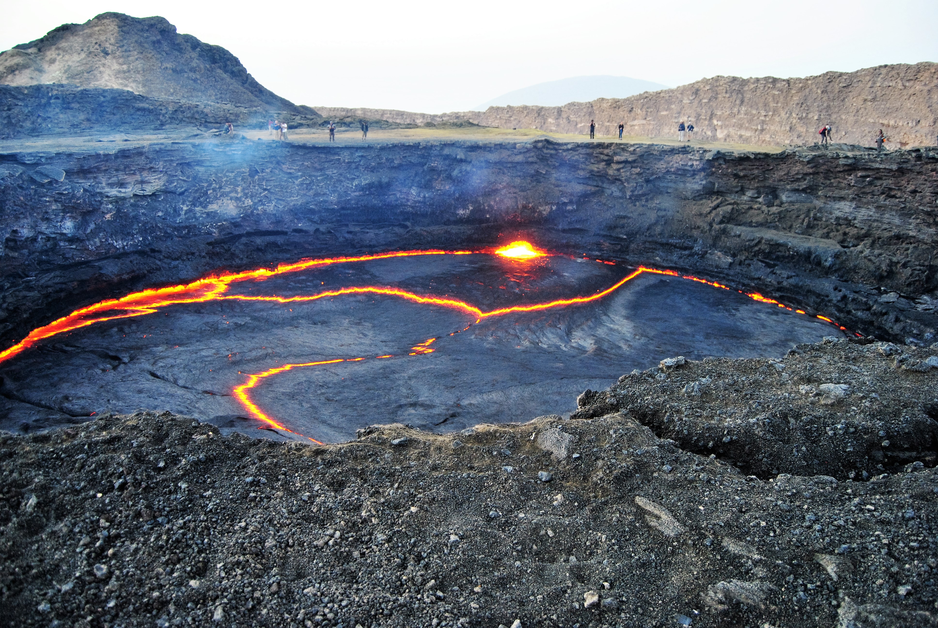
Tourists can get dangerously close to the edge of the lava lake on Erte Ale.
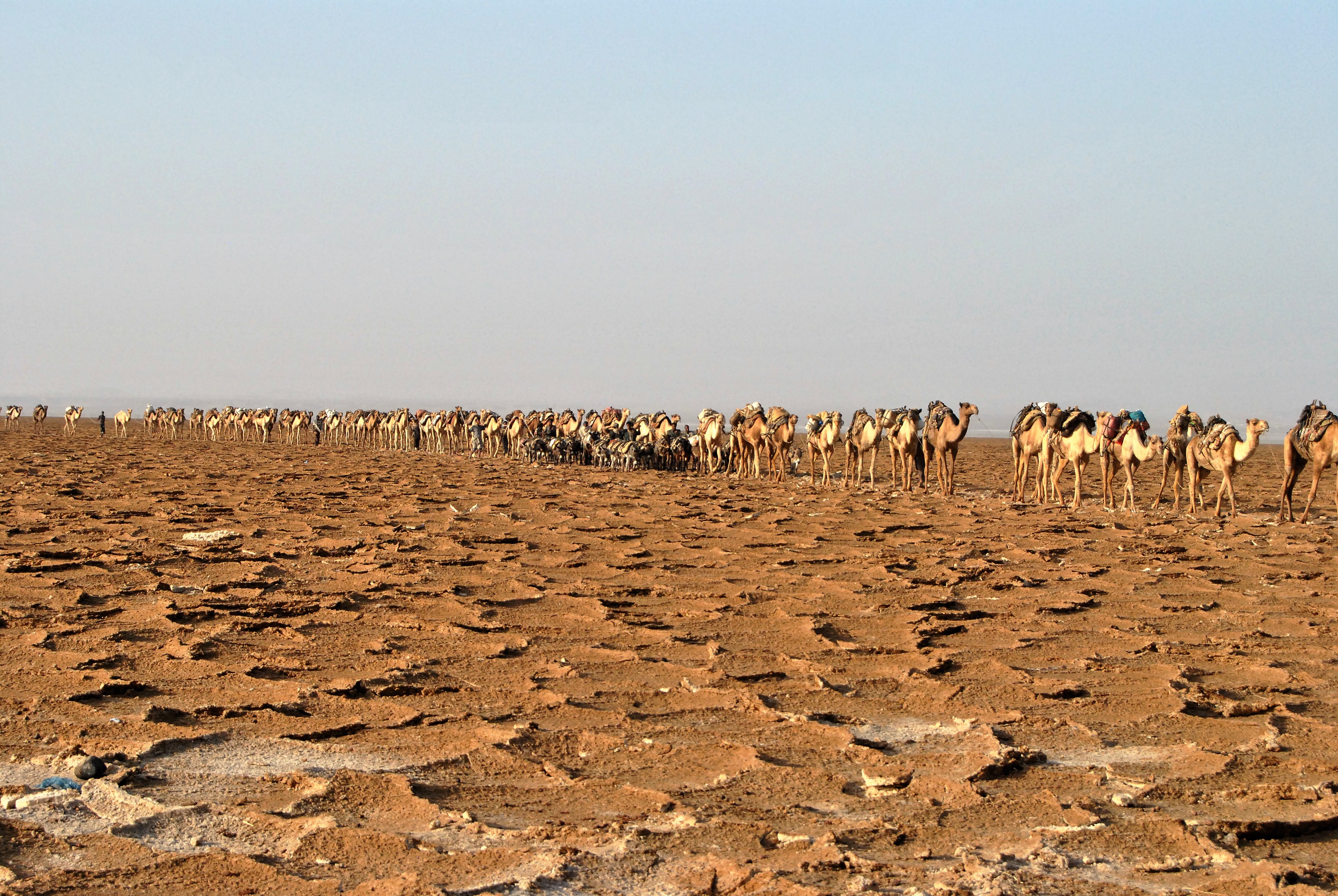
Impressive, kilometre long ‘salt-trains’ of camels and donkeys that carry salt blocks from the salt crusted desert to the nearest town of Makele.
Thinking our trip had reached its climax we were somewhat unenthusiastic about the logistical hassles and possible additional “facilitation” fees leading to our visit of the Dallol sulphur springs the following day. We were however completely amazing and rejuvenated after seeing the impressive, kilometre long ‘salt-trains’ of camels and at last, reaching the famous -139 m altitude near the base of the Dallol volcano. The sheer beauty and vivid colour combinations of the springs is something to behold and happily left us debating what the real highlight of our trip was. Dallol, named after the green acidic ponds by the Afar people, is a volcanic maar or explosion crater that formed when a steam rich eruption (Phreatic eruption) intersected Miocene aged salt deposits (salt resulting from the periodic flooding of the Red Sea in the depression) around 1926. Now the intersection of basaltic magma below the salt-pans sustains the unique sulphuric hydrothermal activity and as recently as 2004 the shallow magma chamber beneath Dallol is said to have deflated which led to multiple basaltic intrusions in the Afar rift system. The landscape around the hot-springs is like nothing on earth and an image of aliens hanging around the orange-red and green salty hydrothermal vents on a foreign planet as if they were office water-coolers is all that you can envisage.
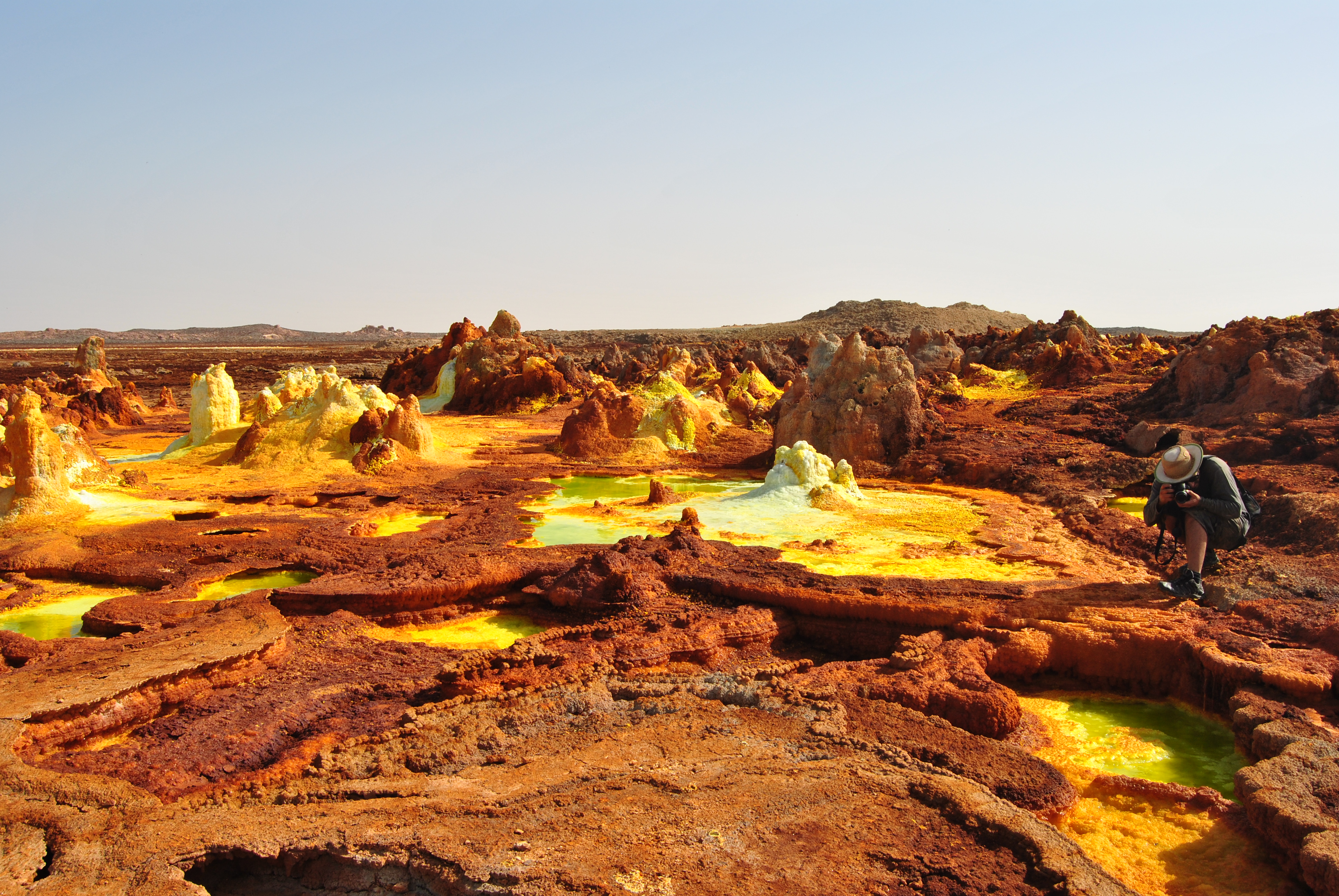
The sulphur springs and Dallol form beautiful terrestrial looking landscapes.
We concluded our adventure in Ethiopia with a scenic two day trip back up the escarpment, to the base of the Semien Mountains at 3000 m and slowly all the way back to Addis-Ababa. Although a flight would have taken 45 minutes from Makele it gave us time to reflect on our adventure “Afar-below sea level” and despite the sweltering heat, daily diet of dry two minute noodles, numerous bumped heads against the 4×4 roof and multiple “facilitation fees” it is clear to see the Depression is far from what its name suggests. For any visitor to the Danakil it is a place of amazing beauty but as a geologist, especially a hard-rock ‘fieldy’ like me it is impossible not to appreciate these forces of geological nature.
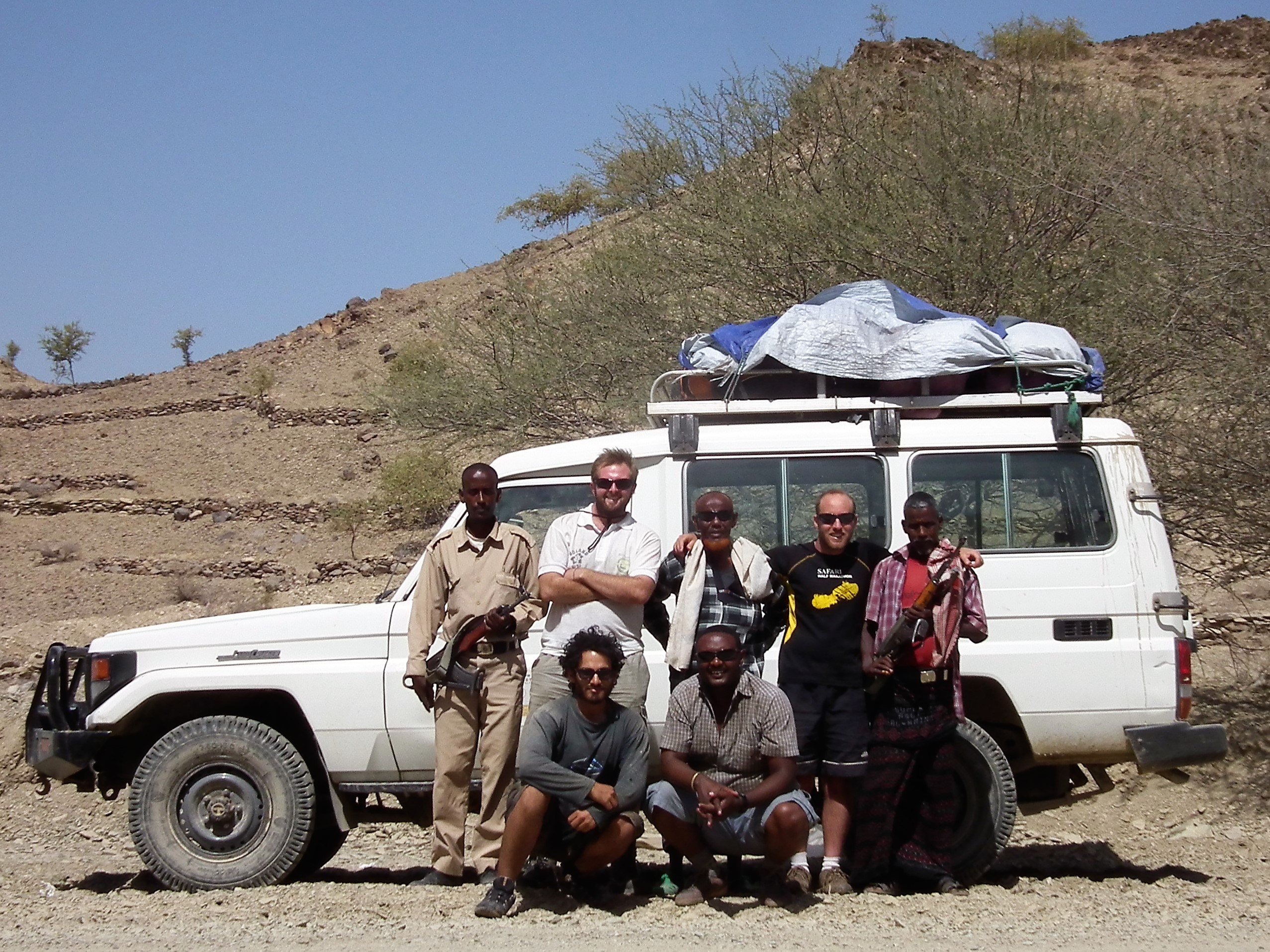
Us three posing in front of the Landcruiser with our translating-driver, Jomo, our guide, Red-Beard and our two armed chaperones.
![]() This work is licensed under a Creative Commons Attribution-NonCommercial-ShareAlike 4.0 International License.
This work is licensed under a Creative Commons Attribution-NonCommercial-ShareAlike 4.0 International License.