Andrew is a postdoc in the Experimental Studies of Planetary Materials (ESPM) group at Washington University in St. Louis. You can find him on Twitter @TectonoAndy and learn more about his research here.
Abel Tasman, one of the first Europeans to explore New Zealand (in 1642), noted that it was a “large land, uplifted high”. He was referring to the Southern Alps; so called by the explorer James Cook, who first mapped New Zealand and after whom Mt. Cook – the largest mountain of the Zealandia microcontinent – was named. Today the Southern Alps stand slightly taller than they would have in 1642 (up to 3.7 m taller, in fact), as the Pacific plate on which the Southern Alps sit, is being actively thrust up and over the top of the Australian plate. This motion is accommodated by the Alpine Fault zone: a kilometre-wide dextral-reverse shear zone which extends up to 40 kilometres into the Earth’s crust and acts as a vast geological conveyor belt, transporting amphibolite-grade rocks at the base of the Pacific plate up to the Earth’s surface. In the upper few kilometres of the crust, this shear zone localises onto the Alpine Fault plane, which runs along the western edge of the Southern Alps and delivers a huge (Mw ≤ 8) earthquake every 330 years on average; the most recent occurring in 1717.
I first arrived in New Zealand in September of 2011, fresh out of my undergraduate degree and ready to start studying for a PhD. Being interested in deformation processes, the Alpine Fault zone was an obvious area of interest and one which would form the foundation of my PhD research. Though I made several visits to the South Island’s west coast for fieldwork, one trip in particular stands out in my memory.
Early in 2013, I set off from Dunedin as part of a team of seven researchers from the University of Otago, Victoria University of Wellington and GNS Science, headed for the west coast. With all of us having similar research interests, we’d chosen to combine our fieldwork to get access to two rather special field sites, and visit some of the more usual ones. Driving from the east to west coast of New Zealand’s South Island takes at least 7 hours, and involves crossing the spine of the Southern Alps. On my first trip to the west coast, I remember being in awe at the landscape which appeared to grow ever higher; rolling countryside turning to foothills and finally mountains which give way to lush rainforest and coastal plains on the other side. Because the Southern Alps form a huge orographic barrier, protecting the east coast from the westerly prevailing winds, it’s not uncommon to pass almost instantaneously from baking, dry heat on the eastern side, to heavy, lashing rainfall on the west coast. In fact, the west coast typically receives 4–10 m of rainfall annually (that’s about three times what the Amazon rainforest gets!). Not only does this make fieldwork a typically soggy undertaking, it also means that many of the Alpine Fault rock exposures are obscured by dense rainforest. Consequently, most fieldwork is confined to creeks which incise the mountains and provide windows into the Alpine Fault hanging wall.
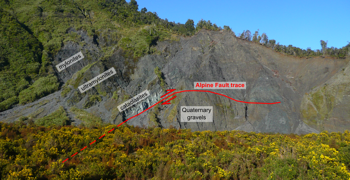
The archetypal Alpine Fault exposure at Gaunt Creek. The Alpine Fault principal slip plane lies at the base of the distinctive mint-green cataclasites, and exhumes a kilometre-wide hanging-wall sequence of mylonites formed at depth.
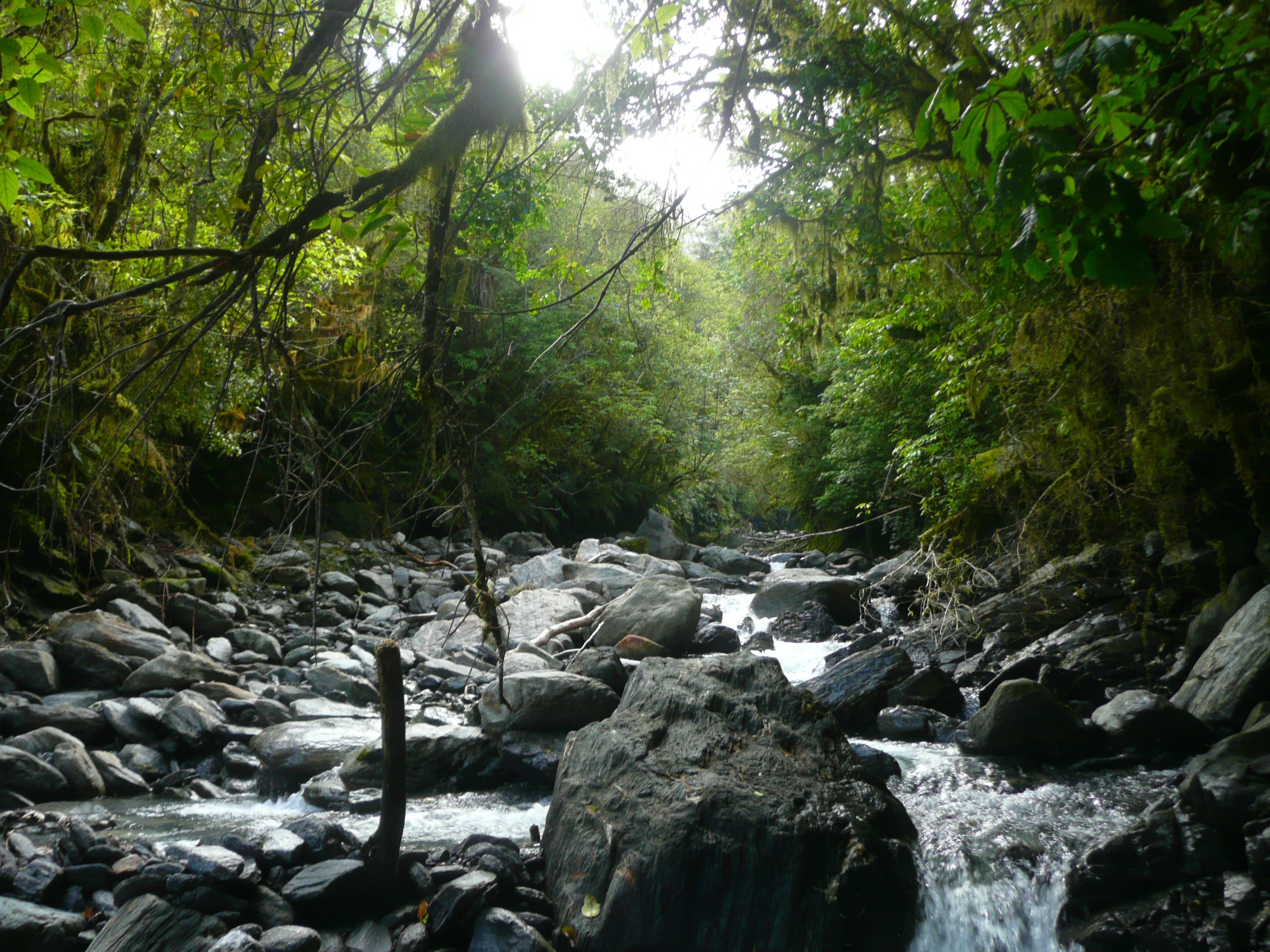
A typical West Coast fieldwork location: Stony Creek near Franz Josef township. Fieldwork is often confined to creeks and rivers which incise the Southern Alps and thick West Coast rainforest, and are lined with exposures of the Alpine Fault hanging wall sequence.
The first stop on the trip was the Amethyst Tunnel near Hari Hari: an ambitious hydroelectric scheme under construction at the time, involving the diversion of water from high up in the Amethyst ravine down a kilometre-long tunnel to a powerhouse. We’d been granted access to the tunnel – containing a near-continuous and complete section through the Alpine Fault mylonite sequence – before the rocks were locked away behind a layer of shotcrete. The two days we spent in the tunnel were among the most unusual and challenging conditions I’ve ever worked in. Being barely lit, we had to work by the light from our headlamps, all the while being showered by water trickling (or rather gushing in places) into the tunnel through the strongly foliated and permeable mylonite overhead. Occasionally, trucks transporting material to and from the surface would pass through, and upon seeing their flashing orange lights we’d have to dive into small alcoves found periodically along the tunnel walls. Though none of us were particularly claustrophobic, it was nevertheless a relief to emerge out into daylight at the end of each day.
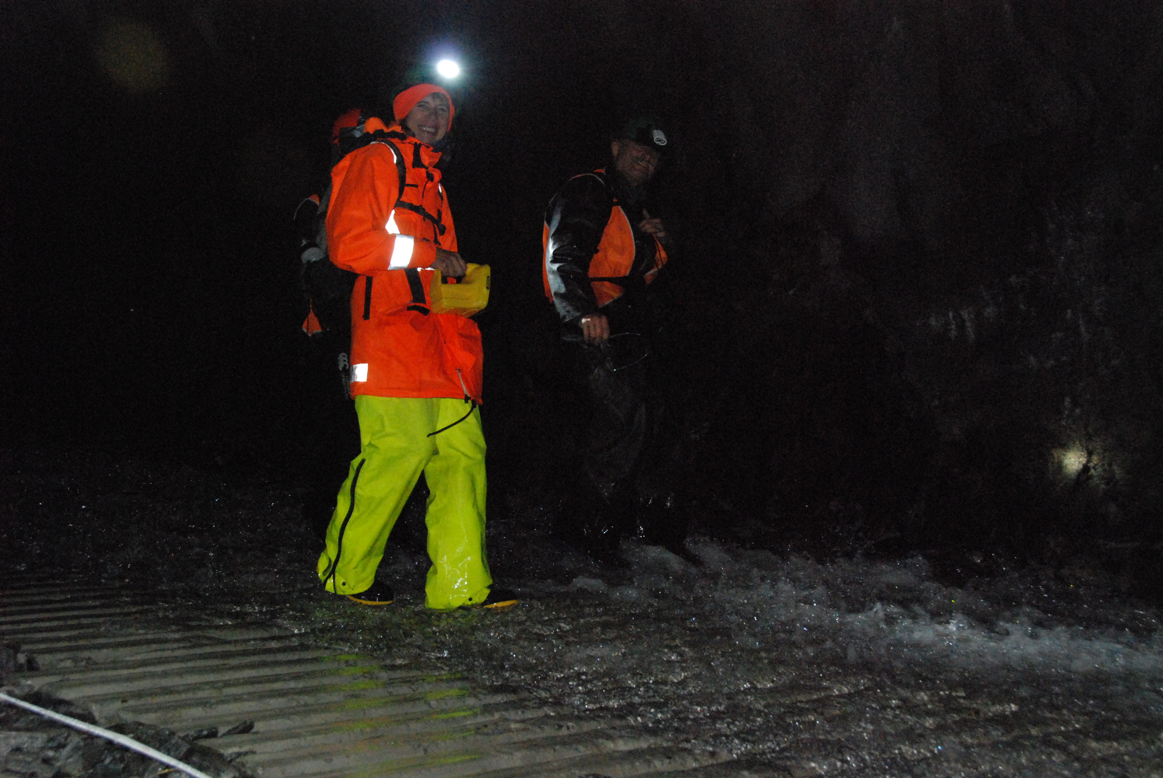
Tim and Susan surveying the Amethyst Hydro Tunnel in wet conditions.
Normality returned for the next few days, which consisted of trips up various creeks to grab samples for microstructural study back in Dunedin. However, one noteworthy day involved us rappelling into a steep-sided ravine to check out a particular exposure of mylonites, only to find that the rocks – exposed at head-height just a couple of years before – had been buried under two metres of sediment! By this point, having been thoroughly soaked by rainfall and two waist-deep river crossings, we promptly retreated back to town and the warmth of the motel hot tub.
The next day we packed up and left for our final fieldsite – a series of rocky ledges and slabs high above the Franz Josef glacier at Crawford Knob. There, an array of quartz veins record brittle-ductile shear originating deep within the crust, formed as the Pacific plate steps up onto the Alpine Fault ramp and develops a conjugate set of backshears dipping antithetic to the Alpine Fault. Though accessible via a steep and notoriously sketchy trail through dense bush, we chose to take the easy route and fly in by helicopter, much to my excitement. This was easily arranged, as Franz Josef township hosts several helicopter companies offering scenic glacier fly-overs to tourists. We were lucky enough to get a particularly scenic flight right up the centre of Franz Josef glacier, gradually rising above the bush-line and into bare Alpine terrain. Over two days up at Crawford Knob we constructed several detailed logs and transects of the brittle-ductile shears, to provide data which might reveal the controlling factors in shear formation, spacing and the ratio of brittle to ductile deformation. Each evening as we ate at camp we were treated to a spectacular light show, as the sun set across the Tasman Sea to the west, bathing the mountains in hues of red and orange. The perfect weather we’d had for our trip wasn’t to last forever though, and on the final morning we were swiftly retrieved by the helicopter company as heavy clouds started to set in. By the time we left Franz Josef less than two hours later, on our way back to Dunedin, the Southern Alps were completely enveloped by rain and cloud and we were quite glad for the warmth of our pickup trucks.
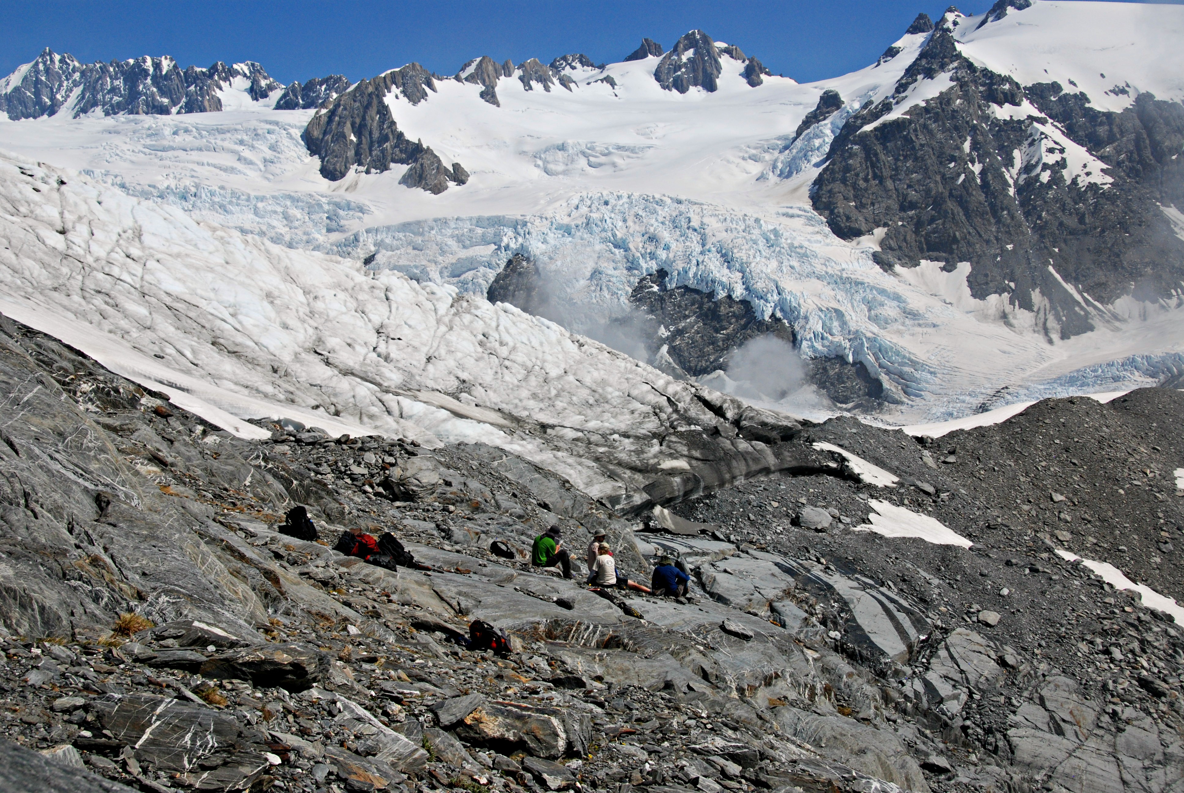
High above the rainforest – lunchtime at Crawford Knob, on the northern flank of the Waiho valley. Photo credit: Dave Prior.
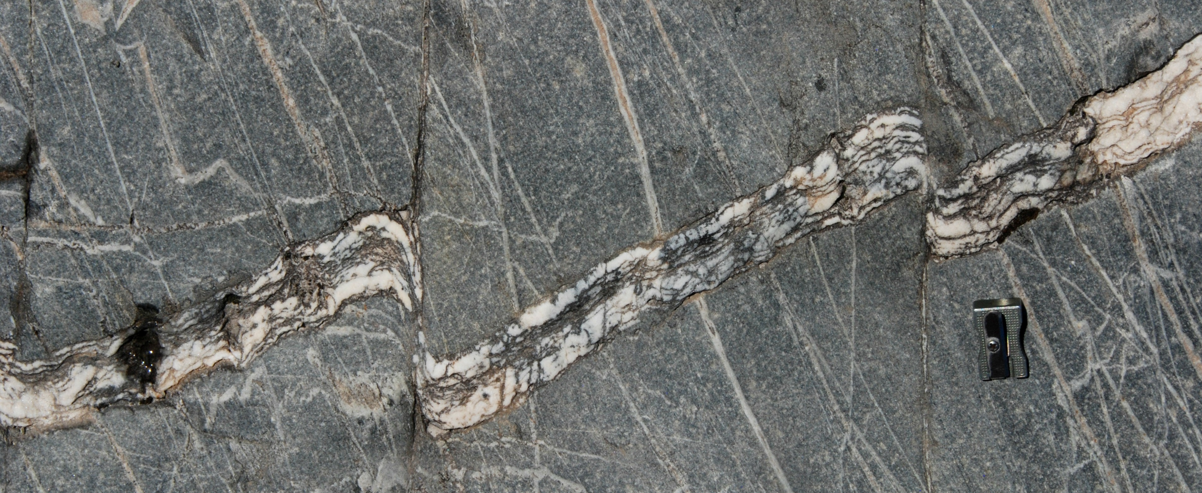
Brittle-ductile shears in quartz veins at Crawford Knob.
![]() This work is licensed under a Creative Commons Attribution-NonCommercial-ShareAlike 4.0 International License.
This work is licensed under a Creative Commons Attribution-NonCommercial-ShareAlike 4.0 International License.