Sallie Burrough is Trapnell Fellow of African Environments in the Environmental Change Institute at the University of Oxford.
By a strange twist of chance, in the dry July months of 2005 I found myself in a remote corner of Botswana asking my brother (who lived there and probably went there to escape the irritations of his little sister) whether I could borrow his car. I was at the very beginning of my PhD research, the purpose of which was to establish when, give or take a thousand years or so, one of Africa’s largest lakes had stopped being a lake and perhaps, by extension, why?
‘The Makgadikgadi’, as the big white depression is known, sits in the middle of the Kalahari basin in Northern Botswana. In it you will find shorelines, spring mounds and stone tools, salt pans, diamonds, dunes and enough dust to change the global climate. It is part of a number of sub-basins that together mark the footprint of a former mega-lake system, Palaeolake Makgadikgadi.
Palaeolake Makgadikgadi lies at the distal end of the Okavango River, which flows all the way from the Angolan highlands into northern Botswana and then largely evaporates within the broad, low lying alluvial fan that sits between the river and the former lake basin, and which is better known as the Okavango delta. Rainfall in the highlands falls in the summer months between November and April and steadily makes a 1500 km journey to flood the landscape 6 months later in the midst of the Kalahari dry season. A little of this flow makes its way into the sub-basins of palaeolake Makgadikgadi (Lake Ngami, the Mababe Depression and the Makgadikgadi pans). Ordinarily, the water that ends up in these basins isn’t much more than a puddle although in the last few years there has been enough standing water in Ngami for boating to become a winter hobby, for kayak trips down the usually dry Selinda spillway into Mababe, and in 2010, the Boteti shocked crocodile and human inhabitants alike by flowing all the way to Rakops for the first time in 30 years. Usually however, it is hard to imagine these flat, dusty depressions as lakes.
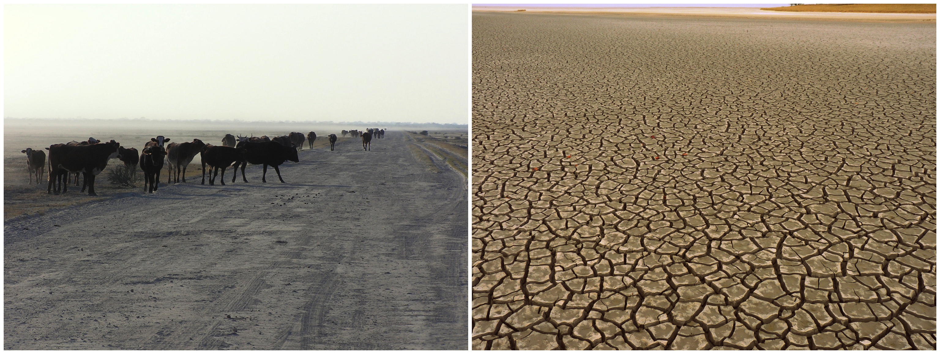
Left: The Ngami basin (Dautsa ridge shoreline just visible in the background). Right: Sua pan in the Makgadigkadi during the dry season.
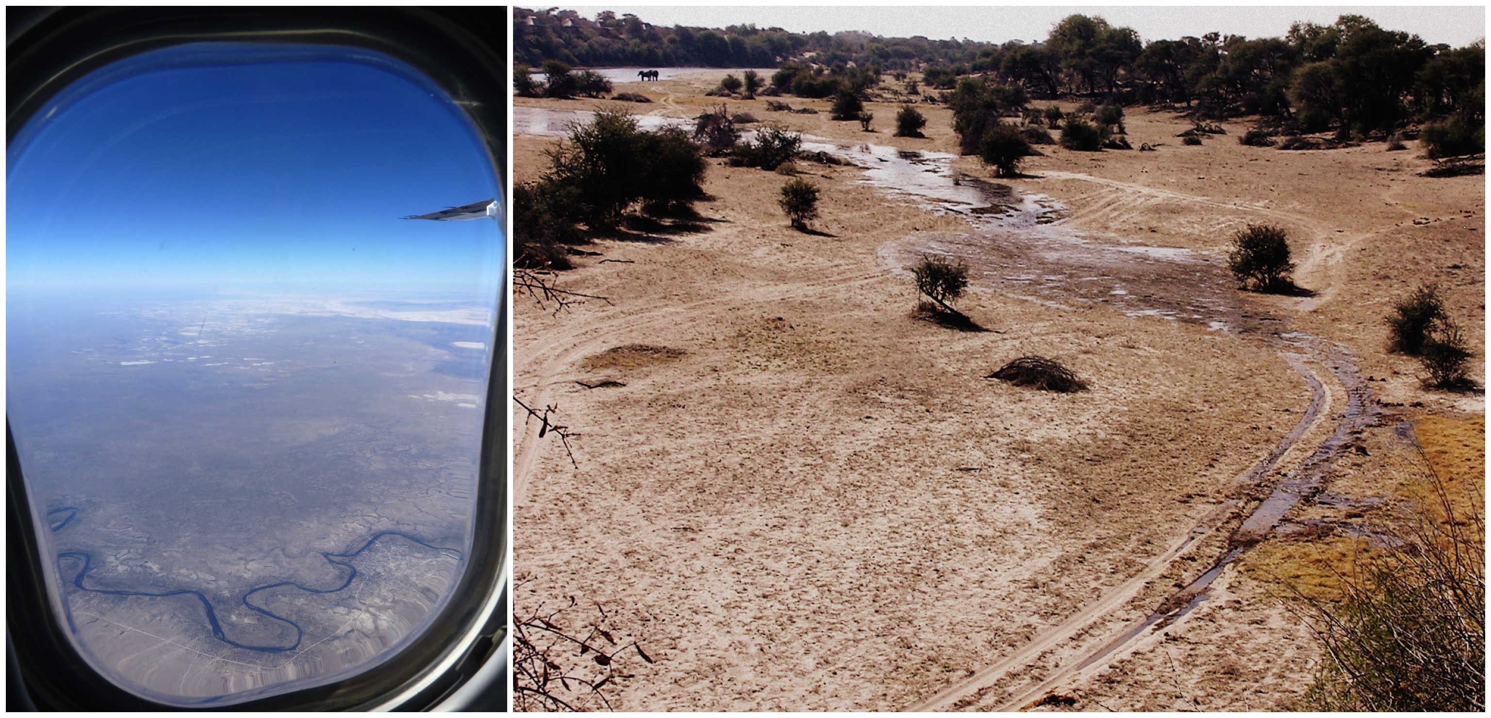
Left: From the air, the Boteti flowing towards Rakops in 2014, the pans visible in the background. Right: Watching the Boteti flow past Khumaga in 2009 for the first time in 30 years.
It was the meticulous landscape mapping of Dick Grove, John Cooke and Paul Shaw in the 1970s and 80s that provided evidence that these basins once held a large expanse of water. Huge arcuate shorelines, now visible from space suggest a lacustrine system larger than any existing body of freshwater on Earth today (~90,000 km2 at the last estimate) once existed here at the heart of the Kalahari. The reason I had pitched up on my brother’s doorstep in 2005 requesting the keys to his Toyota Hilux, was to find and drill these shorelines for sand. Using a geochronological technique called optically stimulated luminescence (OSL) dating, we can determine when these sands were deposited and thus when the lake existed.
Optically Stimulated Luminescence (OSL) Dating
OSL dating uses the time dependent redistribution of charge within quartz and feldspar minerals to date a sediment’s last exposure to light. Exposure to daylight ‘resets the clock’ and effectively returns electrons to a ground state. On burial, naturally occurring alpha, beta and gamma radiation from radioisotopes in the sand together with cosmic radiation provides enough energy to continuously trap charge in geologically stable ‘trap sites’. We can measure the rate at which the mineral is receiving environmental radiation (dose rate) using a gamma spectrometer in the field and/or elemental concentrations of radioisotopes in the lab. Because we can also measure the total trapped charge population by artificially stimulating the sample with light and measuring the luminescence signal using a photomultiplier tube, we can solve the equation for time since burial:
Age (ka) = Palaeodose (Total radiation dose, Gy) / Environmental dose rate (Gy/ka)
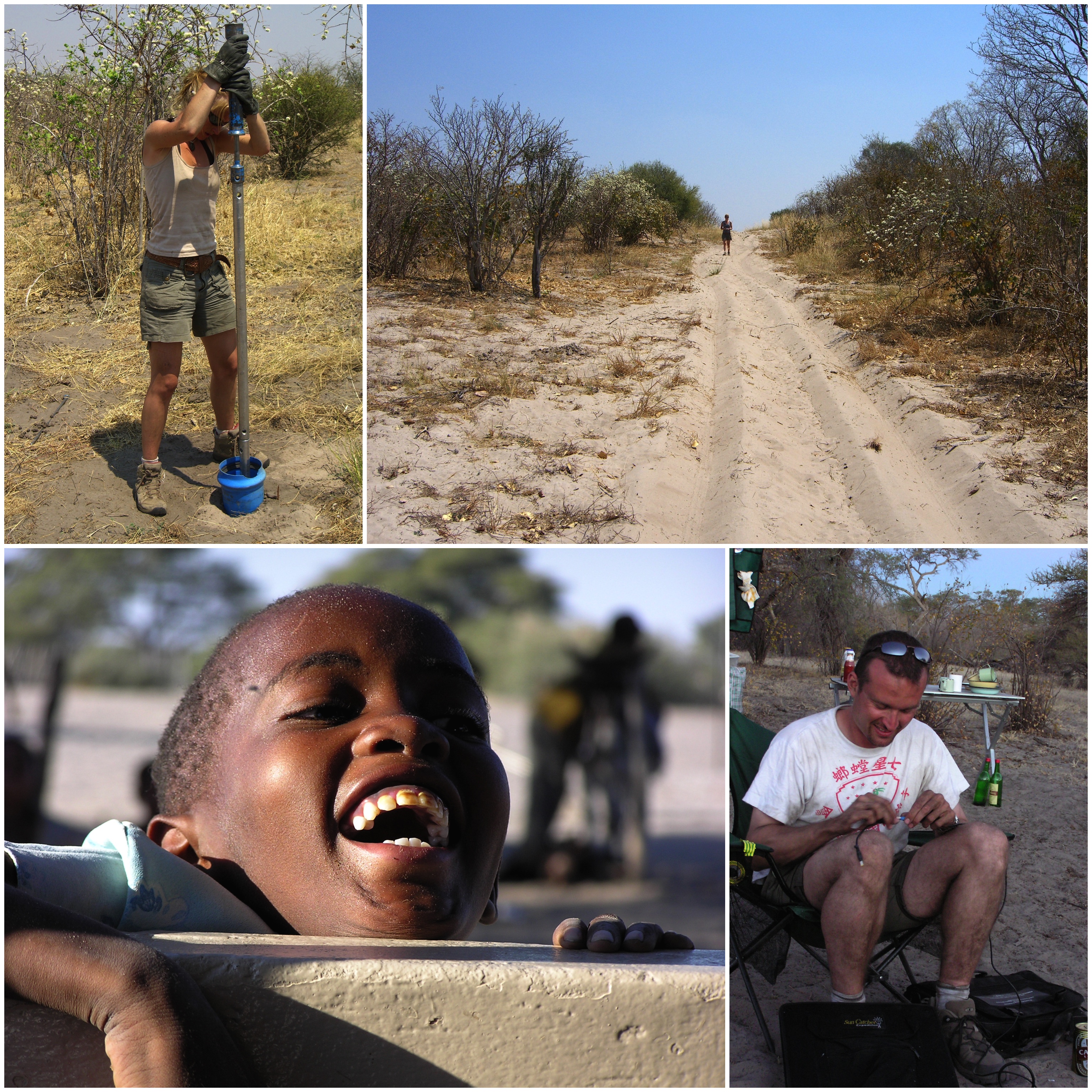
Top: Auguring shorelines for sand samples in the Mababe depression. Bottom left: Messing about with kids in Kareng, Ngami. Bottom right: A colleague tries to fix a solar panel with duct tape to power the gamma spectrometer.
But I am getting ahead of myself. The story of the lake starts sometime in the late Cretaceous, when for reasons we don’t quite understand, the southern African crust was undergoing significant flex. The related uplift of the Kalahari-Zambezi axis eventually severed the link between the Limpopo and the rivers to the north sometime during the Miocene, creating a depression in the interior into which rivers flowing from the north now drained and ultimately formed the ancestral palaeolake Makgadikgadi basin. The continued propagation of the of the East African Rift system into southern Africa and the faulting associated with it, resulted in the progressive capture of the rivers rising to the north into the Zambezi drainage including the Kafue, the upper Zambezi and the Kwando, subsequently depriving the Makgadikgadi basin of its principal inflow and ultimately causing it to dry up sometime in the early Pleistocene.
For some, the story ends there, but if the depositional ages of the shoreline sands are correct then the Kalahari has been far from quiescent since these times. The dynamics of the tropical rainbelt over the late Quaternary (~500,000 years) drove huge hydrological changes resulting in fluctuating lake levels and pronounced vegetation change evidenced in basins across Northern and Eastern Africa. These natural climate cycles and events appear to have had no less a profound effect on palaeolake system dynamics in the middle Kalahari. The OSL ages of basin shorelines suggest these landforms are compound features which have reworked and accumulated sediment during multiple lake high stands providing a depositional record of punctuated lake phases that extends from ~280 to ~9 thousand years ago, the last time all three basins in the palaeolake system held a significant body of water. Palaeolake Makgadikgadi seems to have made regular appearances in the Kalahari, driven by vastly increased discharge in the Okavango and the Zambezi, the latter backflooding into the basin via the Mababe depression. What drives these high flows in the river catchments that feeds this lake is less clear. Interestingly, climate model simulations suggest that once the lake begins to fill up, regional recycling of the water (re-evaporation and subsequent rain out) may actually begin to change the local climate, increasing rainfall by up 15% in the summer wet season. These changes in mean annual rainfall and its seasonality would have not only contributed to a degree of self-sustainability in of the lake but may have very significantly impacted the nature of local and regional vegetation assemblages.
For our ancestors then, the late Quaternary brought turbulent times with frequent, large-amplitude changes in hydroclimate and potentially rapid reorganisations of the Kalahari ecosystem. We know they were a part of this ecosystem because despite a surprising dearth of archaeological investigations, the fluvial and lacustrine systems of the middle Kalahari are littered with the lithic evidence of hominin occupation, including those emerging from the Makgadikgadi lake bed itself.
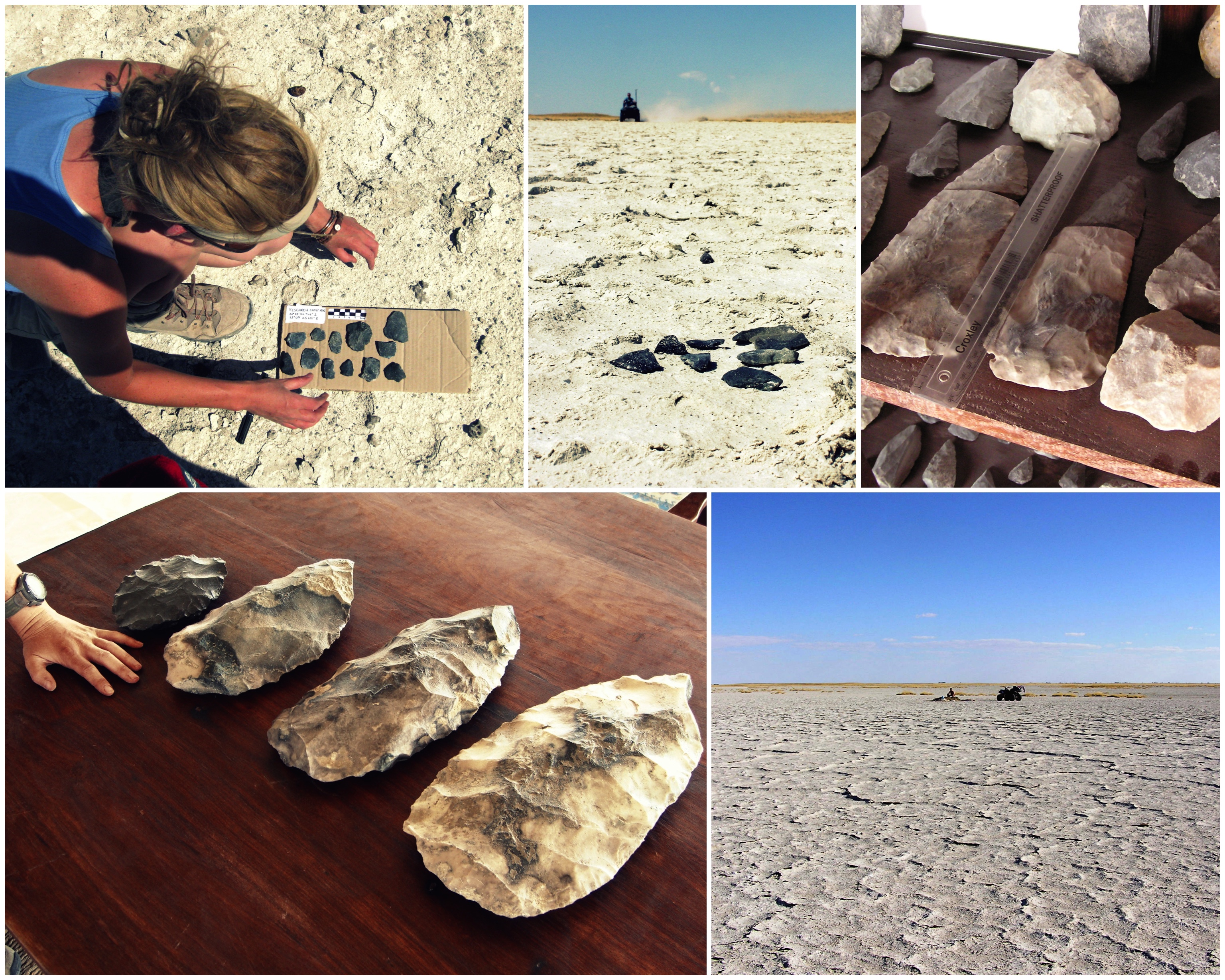
Above: Mapping surface distributions of Palaeolithic tools, the remnants of past inhabitants of the Makgadikgadi basin. Lithic tools are predominantly MSA within the Makgadikgadi complex itself but components of these assemblages are extraordinary including what are likely to be some of the largest hand axes in the world (bottom left – my hand for scale).
Little is known about who these people were, when and why they were here. Scant evidence suggests the stone tools we find littered in the lake mud were dropped there during low lake levels and are probably the relicts of stone-age hunting camps as ancient humans followed the migrations of vast herds of zebra and wildebeest into the pans, the vestiges of which still make the annual march in their thousands today. This research is ongoing and there is much to learn about Makgadikgadi’s past inhabitants.
Makgadikgadi is many things to many people, a salt flat, a superlake, a safari destination for the particularly intrepid. To me, it has become an old friend, an enduring research enigma to chip away at. Within its shorelines I have discovered extraordinary friends, been variously roped into chasing zebras, staking out hyenas in the middle of the night, and searching for missing meerkats. Not long after I finished my PhD and finally stopped filling his car with sand, my brother even got married here. Almost no one leaves this lake bed without an affecting sense of humility and perspective. Against my better scientific judgement, part of me is extraordinarily glad this big expanse of mud and salt and silcrete isn’t likely to give up all its secrets at once. I hope this old lake and I will be stubborn friends for many years to come.
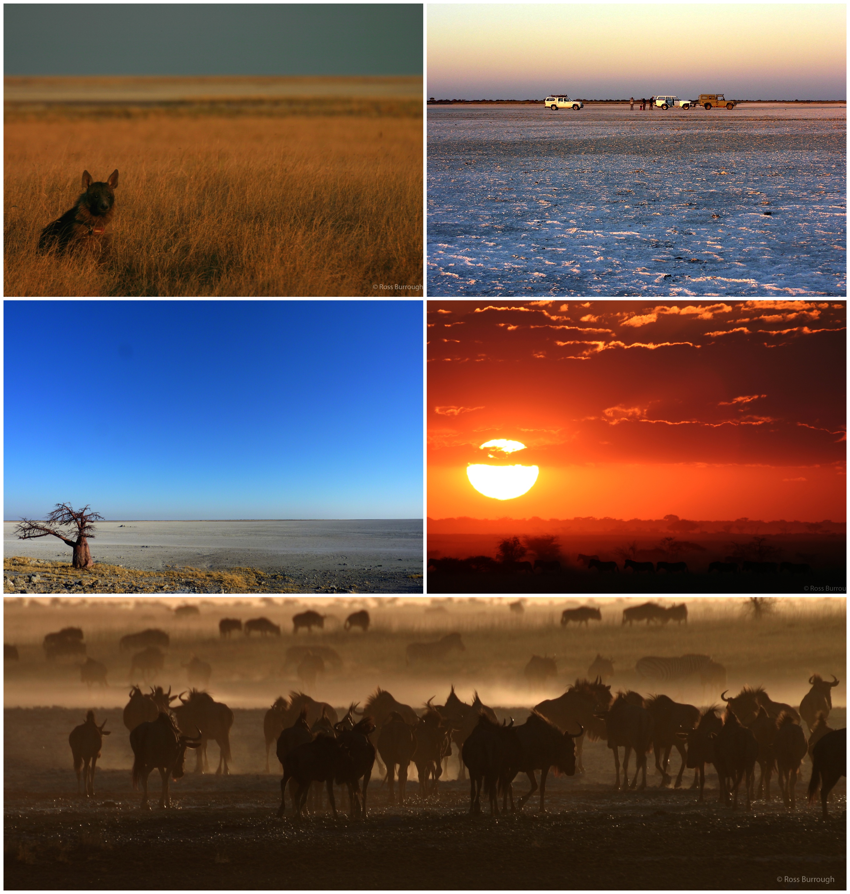
Top left: Venus, a brown hyena going about her daily business in the old lake bed, she was collared as part of a research project attempting to establish more about these little known elusive creatures (photo by Ross Burrough). Top right: Sundowners with friends and researchers on the pan. Middle left: Kubu Island, with its iconic baobab trees dating the high-water mark here to > 3000 years. Right and bottom: The migration of thousands of zebra and wildebeest into the pan during the wet season, these numbers have vastly reduced over the last 50 years (photos by Ross Burrough).
I am indebted to my brother Ross and my brilliant colleagues both inside and outside Botswana for their support in carrying out this research.
You can read more about some of it here:
Burrough, S.L. and Thomas, D.S.G. (2013) Central southern Africa at the time of the African Humid Period: a new analysis of Holocene palaeoenvironmental and palaeoclimate data. Quaternary Science Review, 80: 29-46.
Burrough, S.L., Thomas, D.S.G. and Singarayer, J.S. (2009) Late Quaternary hydrological dynamics in the Middle Kalahari: Forcing and feedbacks. Earth Science Reviews, 96(4): 313-326.
Burrough, S.L., Thomas, D.S.G. and Bailey, R.M. (2009) Mega-Lake in the Kalahari: A Late Pleistocene record of the Palaeolake Makgadikgadi system. Quaternary Science Reviews, 28(15-16): 1392-1411.
![]() This work is licensed under a Creative Commons Attribution-NonCommercial-ShareAlike 4.0 International License.
This work is licensed under a Creative Commons Attribution-NonCommercial-ShareAlike 4.0 International License.