Anouk Beniest is a PhD candidate at the University Pierre et Marie Curie in Paris, France. She works on continental rifting and break-up processes, with a focus on the South Atlantic domain. She got the chance to join a scientific cruise in the Indian Ocean on a German research vessel, ‘Sonne’, for the acquisition of seismic, magnetic and gravimetric data.
A warm, blue ocean stretches as far as the eye can see in all directions. The water is over 4000 meters deep, too deep for swimming. The weather is calm now, even for monsoon times, which is a good thing because I can adapt easily to the ocean’s motions. I am standing on the Monkey Island of a German research vessel, Sonne. The vessel left from the harbour of Colombo, Sri Lanka, and traces the 81o E longitude southwards. The empty quarter of the Indian Ocean lies right in front of me. The southern-most point of this trip is 11° 30´ S. The cruise will take me back and forth between the northern and southern hemispheres several times. On the other side of the ocean lies Antarctica that was once connected to India and Sri Lanka. The aim of the cruise is to understand more about the break-up history of Antarctica and so we trace back how India fled from Antarctica by gathering all types of geophysical data. As soon as we pass the nautical highway in front of Colombo deployment of the first equipment begins. The first acquisition instruments that need to be put into place are the magnetometer and the hydro-acoustic equipment.
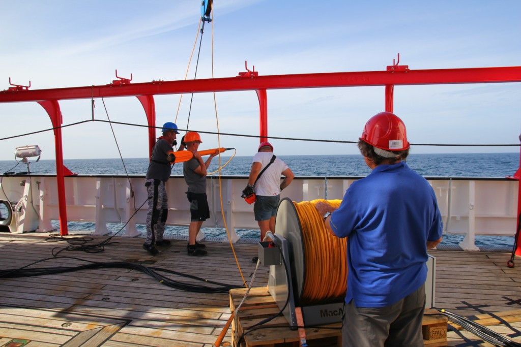
Photo 1. Deploying the magnetometer. A magnetometer measures the intensity of the magnetic particles in the rocks. Whenever there is a change in intensity, we have found an anomaly. There is a variety of reasons for magnetic anomalies to exist. They could be due to crustal features such as faults, or as a result of a change in chemical composition, for example an elevated amount of magnetite. Here, we are interested in the magnetic minerals in the oceanic crust that have captured polarity changes of the Earths magnetic field. (Photo by Konrad Behnke, 2017)
While the magnetometer is recording and the hydroacoustic equipment produces high-frequency beeps, the ship is heading further south. We reach the equator and the weather is about to change. I am standing again on the Monkey Island, the highest deck on the ship where scientists are allowed to come. Dark clouds are rolling in and the wind is blowing so strong that I have the impression my eyelashes are blowing away. Despite the dark sky, the ocean still has its dark blue colour and suddenly a group of spinner dolphins turns up out of nowhere. There at least 30 of them as they jump out of the water, doing little tricks.
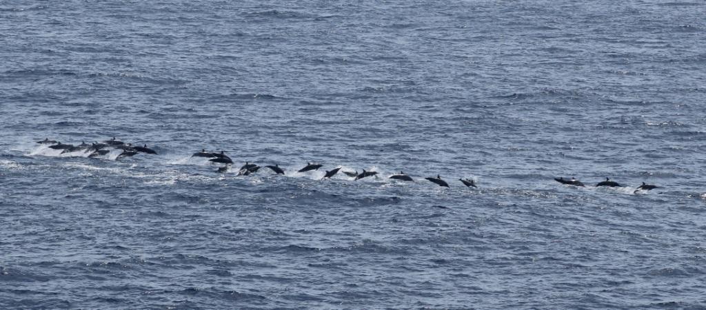
Photo 2. Spinner dolphins speeding our way. There are three marine mammal observers on board. During day-time they watch for whales, dolphins, turtles and other wildlife. Once the airguns are working for seismic data acquisition, the observers have to watch that no marine mammal comes to close to the vessel as it might damage their hearing and the orientation. Once a marine mammal is observed, a shutdown of the airguns is being requested by the observers until the animals are gone. (Photo by Marcus Bridge, 2017)
Clouds are covering the sky now and the waves have reached heights of over 5 meters. When on deck, the waves sometimes reach above me, which is very impressing. In the eating room the salt and pepper has been removed from the table as they wouldn’t stand straight anymore. In the lab everything rolls from left and right and front to back. It is time to learn some knots and secure all the equipment. The storm remains for a couple of days but there is no time to lose and so I prepare my first Ocean Bottom Seismometer (OBS) station while the ship is dancing with the waves. While I am testing my balancing skills I somehow manage to attach the different OBS equipment items to the brightly coloured floating devices. From time to time a wave floods the deck, making the whole scene quiet dynamic. My fellow scientist colleagues prepare the streamer and the airguns. The OBS stations and streamer will be deployed as soon as the longest magnetic profile is finished.
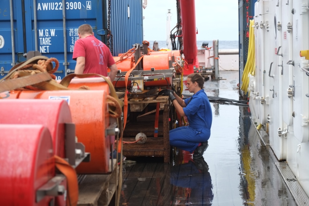
Photo 3. Preparing the OBS stations on deck. Releaser, flash light, radio beacon, pressure tube, hydrophone and geophone are all attached to the floating device that is again attached to an anchor, before deployment. (Photo by Mareen Lösing, 2017)
When the first OBS station, #301, is being assigned to the ocean bottom, all hands are on deck. Everybody is curious about the deployment procedure. To me, it is completely alien to throw heavily coloured equipment overboard and hope that they will surface again, but apparently this works. For two days and two nights I work my shifts to deploy all the stations. In the early morning of the second night, the last station is thrown into ocean. We watch a beautiful sunrise and treat ourselves on a well-earned cold drink. Then I go back to my cabin and dream about oceans full of floating OBS stations.
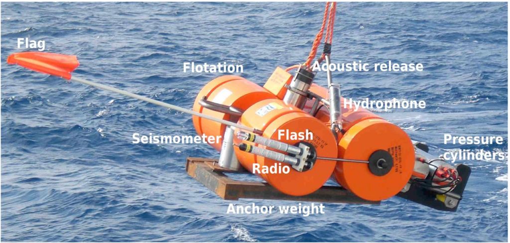
Photo 4. An OBS system consists of many parts. First, a recording system is needed inside a pressure tube. For this cruise, it needs to hold pressures up to 4500 m depth, the maximum depth we expect for this cruise. The recorder records hydrostatic pressure changes with a hydrophone and records refracted and reflected seismic waves through a geophone or seismometer. These are all attached to a floating device that should bring the whole system back up after the seismic profile has been shot. To bring the system down, the OBS is attached to an anchor with a releaser. A releaser is the only connection between the OBS and the anchor and replies to high-frequency sounds as sound is the only way to communicate through water. When the correct frequency is heard by the releaser, it will let go of the anchor and the OBS makes its way back to the surface. (Photo by Tabea Altenbernd, 2017)
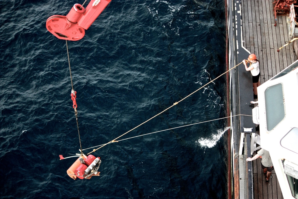
Photo 5. Deploying OBS stations. Every 12-15 kilometres an OBS station is thrown overboard. With the anchor positioned correctly, they should reach the bottom in little time. It is important that the anchor sinks well into the sediments, because only then will the geophone record the refracted and reflected waves produced by the airguns. (Photo by Menaka Goonewardena, 2017)
The morning shift deploys the airguns into the water. It is quiet a violent business as they are very heavy and bump against the back of the boat. The first seismic profile runs north-south and starts on the platform with only 400 meters water depth, close to the continent. It crosses the shelf to the deep ocean with roughly 4500 meters water depth. The shelf is the perfect area for marine wildlife and so the whale watchers have an intensive look-out to make sure no sea mammals are in the vicinity of the ship before the soft-start of the airguns begins. The shelf is also the perfect place to investigate how India broke apart from Antarctica as it records the whole break-up to spreading history.
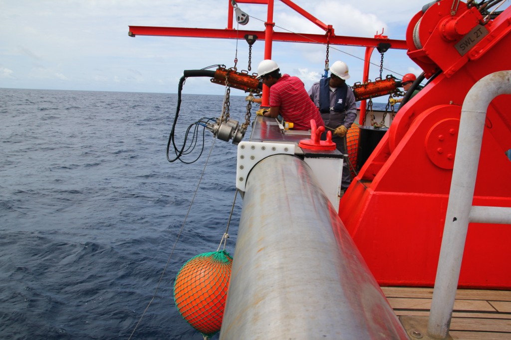
Photo 6. Deployment of the airguns. The seismic installation has 8 airguns, 4 on each side. They are programmed to release high air pressure every minute. Air-pressure will rise to 200 bar before discharging. This produces a seismic signal that the geophones and hydrophones can record. The orange balloons are connected to the airguns so they remain close to the surface and to show where they are located in the water. (Photo by Konrad Behnke, 2017)
The scientific team counts 26 people and during the data acquisition there are 4 hour watches day and night. Per watch, three people take care of quality control and airgun performance. In the meantime, we also prepare OBS recovery and the next seismic profile. But it’s not only work on the ship. There is some free time on board. For the sportive ones there is a gym, a table tennis table and a football table. There is also a library and a large television screen to watch movies. Even a sauna is installed complete with relaxing chairs on the sun deck. Every now and then there are events such as seminars given by the scientists, poker evenings, movie nights and birthday parties. Everybody is invited, both crew and scientists.
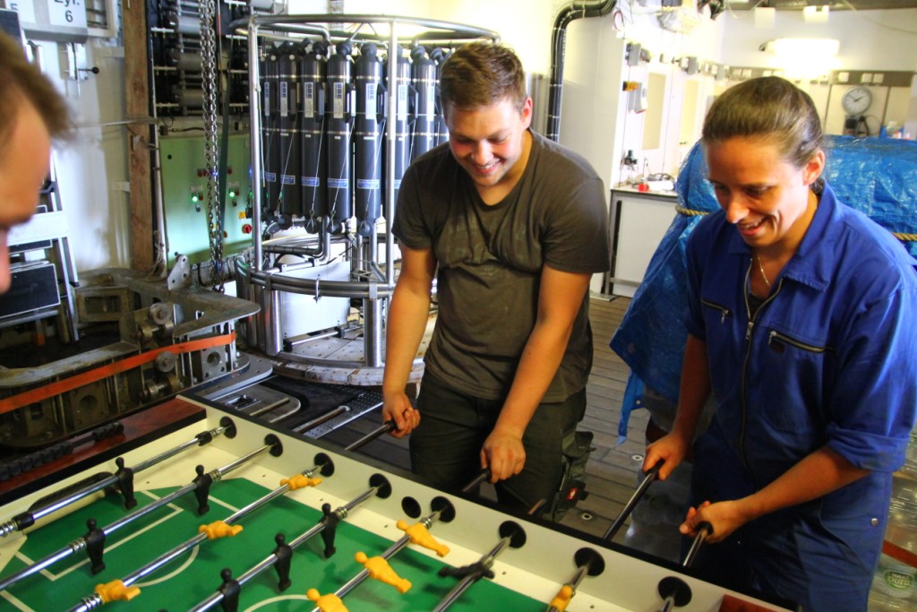
Photo 7. Football table competition during OBS deployment. It takes roughly one hour between the OBS drop-off locations and so we try the football table to kill some time (Photo by Konrad Behnke, 2017)
With five knots per hour, the vessel sails along the profile. At the end, it makes a turn and the recovery of the OBS stations starts. The whole OBS team is restless. Will the releaser pick up the signal and let go of the anchor? We wait for a long time, but then the bridge relieves us from our worries, the radio picked up a signal! The OBS station surfaced! The watchman has already spotted the device and the vessel heads towards the yellow, floating unit. On the deck the crew-members are ready to rescue the OBS station from the water using hooks and ropes. The recovery also continues night and day. My cabin is located on the second deck, close to the surface of the sea. I have bull’s eye windows and during the night I can see the OBS stations flashing by.
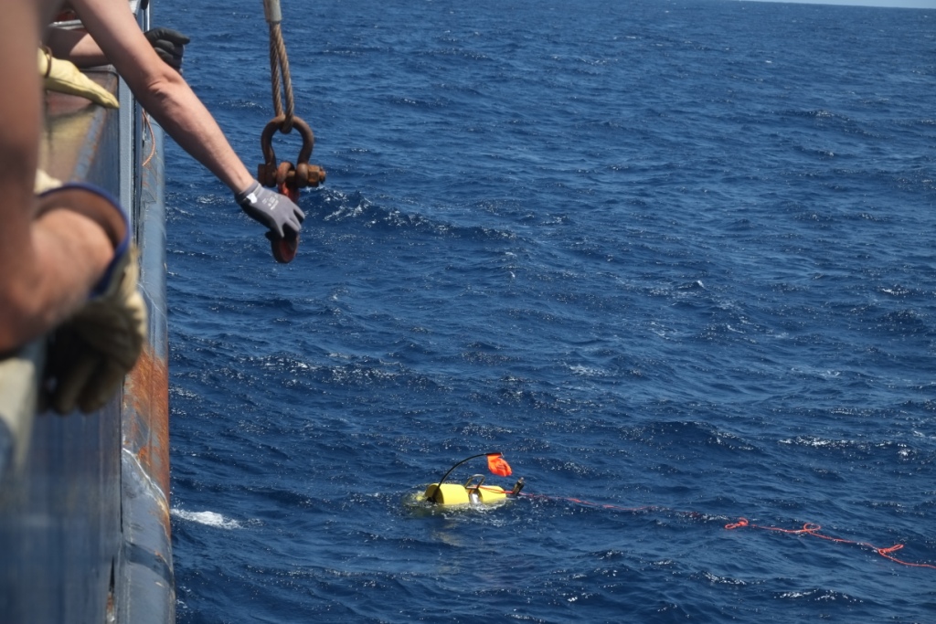
Photo 8. OBS recovery. The OBS rises with 0.9 m/s to the surface. With a depth of over 4300 meters, the ascent takes roughly 80 minutes. When there are strong currents, heavy waves or bad weather they are not so easy to spot. Luckily the OBS station is equipped with a radio beacon and when they reach the surface the radio picks up the signal. They also have a flash light so it can be easily spotted at night (Photo by Mareen Lösing, 2017)
The recovery is going according to plan. OBS after OBS surfaces and gets safely back on the deck. The ocean remains blue and wavy. There is not much to disturb that few. Every now and then a lonely fisherman’s boat passes the ship, but other than it is quiet empty on this side of the world. The weeks pass by quickly. In total, we measured two seismic lines with OBS’s and streamer. We acquire 10 magnetic profiles and cover whatever we have sailed with bathymetry. Processing the data would be the logical next step, but most of this will be done back in our labs. The RV Sonne is used for many different research purposes and so the boat is not permanently equipped with OBS stations or a streamer. Packing all the equipment in containers, so the next cruise starts with a clean ship, is our last task before we get back to harbour of Colombo.
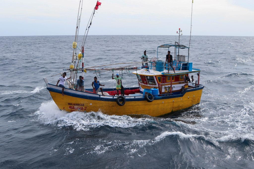
Photo 9. A fisherman boat on the Indian Ocean. Men on boats like these are often at sea for over a month. They only come back ashore when they caught some fish. Sometimes these boats have some places to store fish, but often this is lacking. There is not much luxury on these kinds of boat. (Photo by Marc Hiller, 2017)
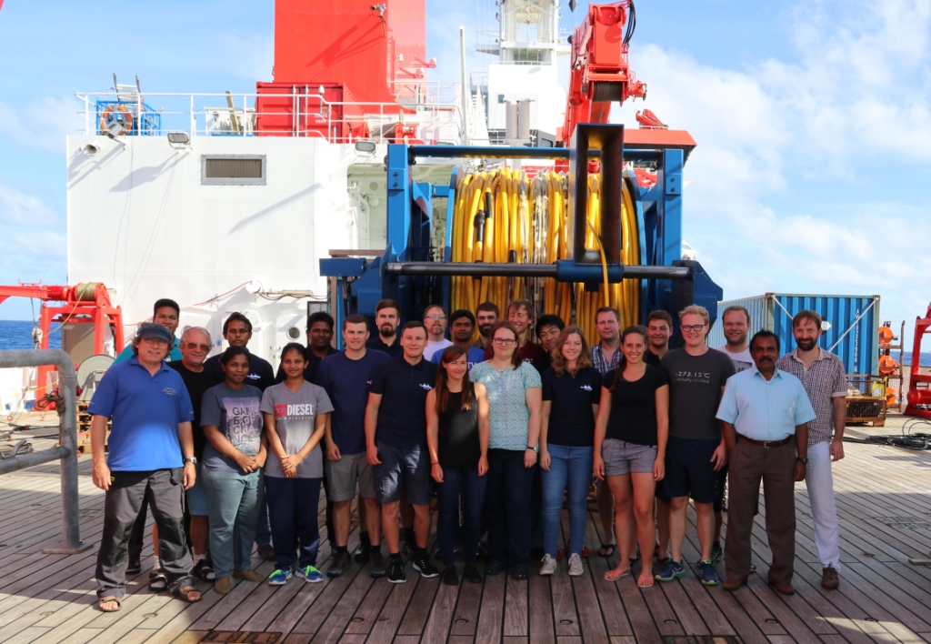
Photo 10. The science party of the INGON cruise Leg 258b. We left Colombo Harbour with the RV Sonne on the 12th of July 2017. The aim of the cruise was to gather more subsurface data along the Sri Lankan continental margin. Once, India and Sri Lanka were attached to Antarctica. The break-up to spreading history is recorded on the margins of the continent and in the oceanic crust. With the magnetic data acquired during this cruise, we investigate the magnetic pattern and thus the age of the oceanic crust and the timing of the spreading history. The OBS stations record both reflected and refracted waves, giving inside in the crustal structure of the margin. Do the margins contain volcanic material? Where does the continental crust change to oceanic crust? The hydro-acoustic data provided information on the ocean floor, which in this case was quite flat except for one deep-sea channel. On the 17th of August 2017 the vessel docked again in the harbour of Colombo. (Photo by Wolfgang Borchert, 2017)
![]() This work is licensed under a Creative Commons Attribution-NonCommercial-ShareAlike 4.0 International License.
This work is licensed under a Creative Commons Attribution-NonCommercial-ShareAlike 4.0 International License.