At 11.56 am Nepal time an earthquake of magnitude Mw 7.8 struck near Gorkha in the Nepal Himalaya (Fig. 1, 2). The epicentre of the earthquake was approximately 34 km ESE of Lamjung, 77 km WNW of Kathmandu and 73 km east of Pokhara. The hypocentre was at a relatively shallow depth of 15 km. The focal mechanism suggests it was a compressional thrust fault that resulted in up to 4.5 meters of slip beneath the Kathmandu valley. Aftershocks ripped off eastwards from the epicenter causing a fault rupture up to 150 km long running east of Gorkha. The fault did not slip to the west so the fault remains worrying locked in that region. The following day several aftershocks up to Mw 6.7 occurred as the plates readjusted. It is expected that aftershocks will continue to occur throughout Nepal related to this earthquake. The official death toll is in excess of 7000, but the true figure is likely to be a lot more once news from remote villages comes in.
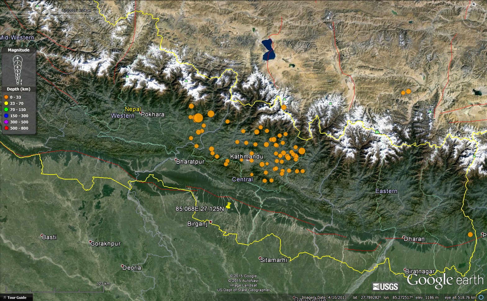
Figure 1. Google Earth image of Nepal showing location of the 25th April Gorkha earthquake and its aftershocks, courtesy of USGS.
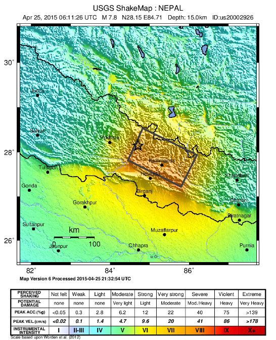
Figure 2. Shake map showing the intensity of ground shaking around the Gorkha earthquake, USGS.
Synthetic Aperture Radar Interferometry (InSAR) recorded the post-earthquake ground motions around the area from European Sentinal-1a satellite by comparing the imagery before and after the earthquake. Each colour contour on the interferogram shows 2.8 cm of ground movement with respect to the satellite (Fig. 3). The data shows that an area approximately 120 km by 50 km around Kathmandu lifted up by at least 1 meter. As the thrust fault ruptured, the hanging-wall tilted with rocks immediately above uplifting and the surface to the north actually subsiding. This is to be expected from thrust faulting earthquakes.
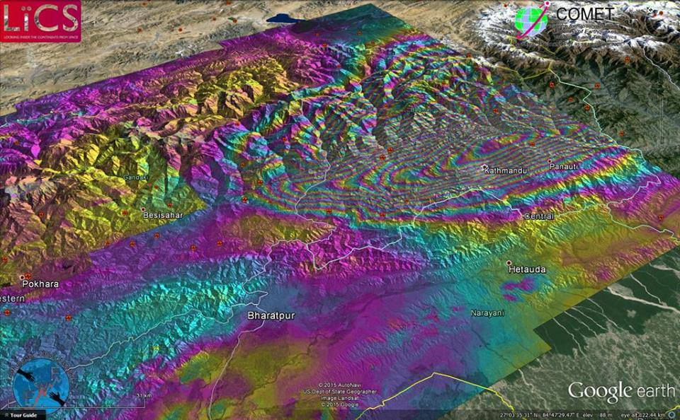
Figure 3. Synthetic Aperture Radar Interferometry (InSAR) showing ground surface motions after the earthquake, courtesy of John Elliott (COMET, University of Oxford). Maximum motion occurred north of Kathmandu where the surface rose by ~ 1 meter.
The 25th April Nepal earthquake caused extensive damage. Villages along the Burhi Gandaki valley north of Gorkha around the epicenter were affected particularly badly (Fig. 4). Several villages had almost all houses flattened by the quake. Thousands of people were killed and injured and most were left homeless. Landslides blocked the Burhi Gandaki hindering access. In Kathmandu ancient temples in Durbar square collapsed (Fig. 5) and the famous landmark Dharahara tower collapsed causing many fatalities (Fig. 6). In Durbar square, Bhaktapur old temples were reduced to rubble (Fig. 7) and the ancient city of Patan suffered even worse damage with numerous buildings collapsing (Fig. 8). The Kathmandu valley is built on old lake sediments which, during intense shaking can result in solifluction of liquification, hence the reason most of the worst affected areas were in the Kathmandu valley.
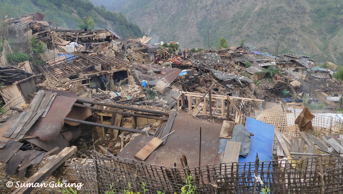
Figure 4. Destruction of Laprak village in the Burhi Gandaki valley, north of Gorkha, photo courtesy of Suman Gurung.
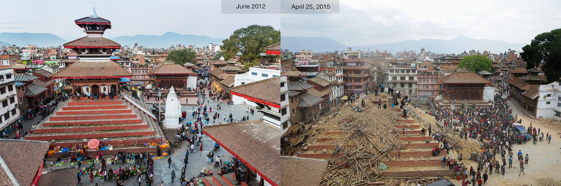
Figure 5. Before and after pictures of Durbar square in Kathmandu, courtesy of National Geographic.
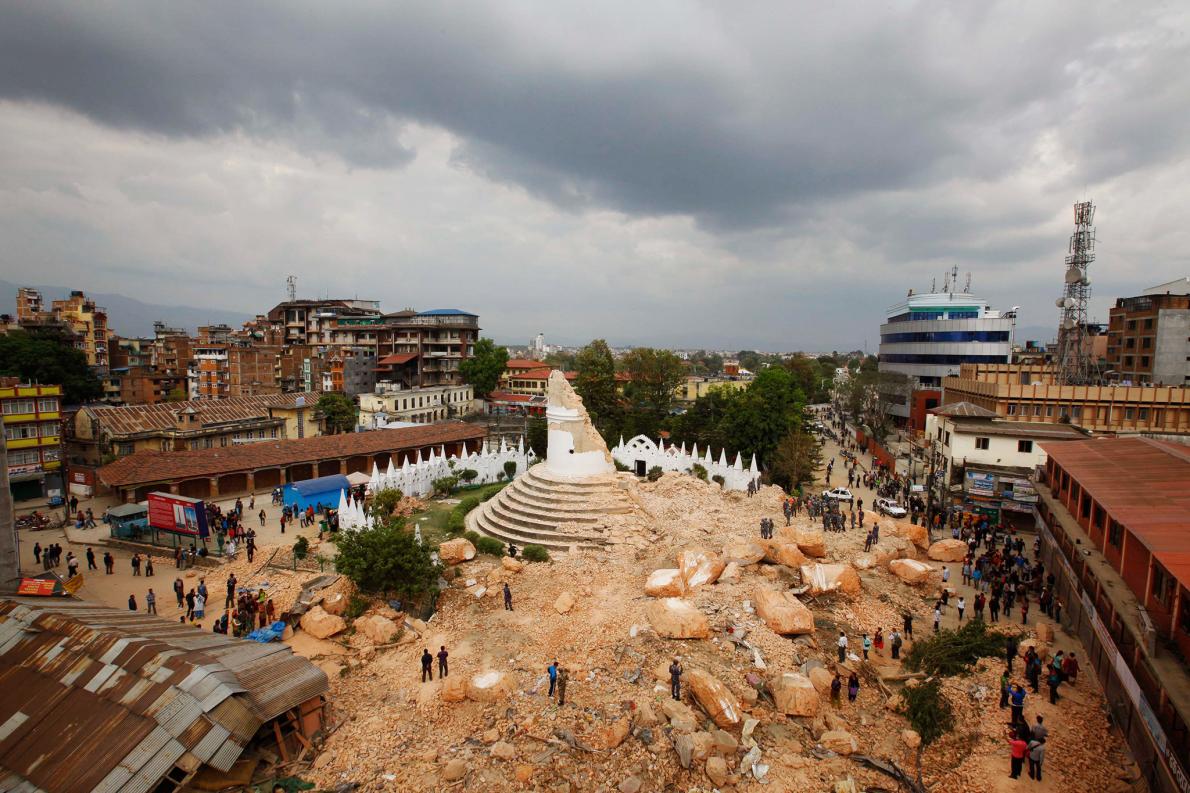
Figure 6. The Dharahara tower in Kathmandu collapsed during the earthquake, courtesy of National Geographic.
The earthquake loosened a lot of rock at high altitude which resulted in devastating rock and ice avalanches. The worst known such avalanche completely buried the village of Langtang covering three storey houses and killing everyone, more than 450 people. The avalanche came down the south face of Langtang Lirung and filled the valley (Fig. 9). On Everest the earthquake set off numerous avalanches which swept down the south and SW face destroying the route through the icefall and trapping climbers above.
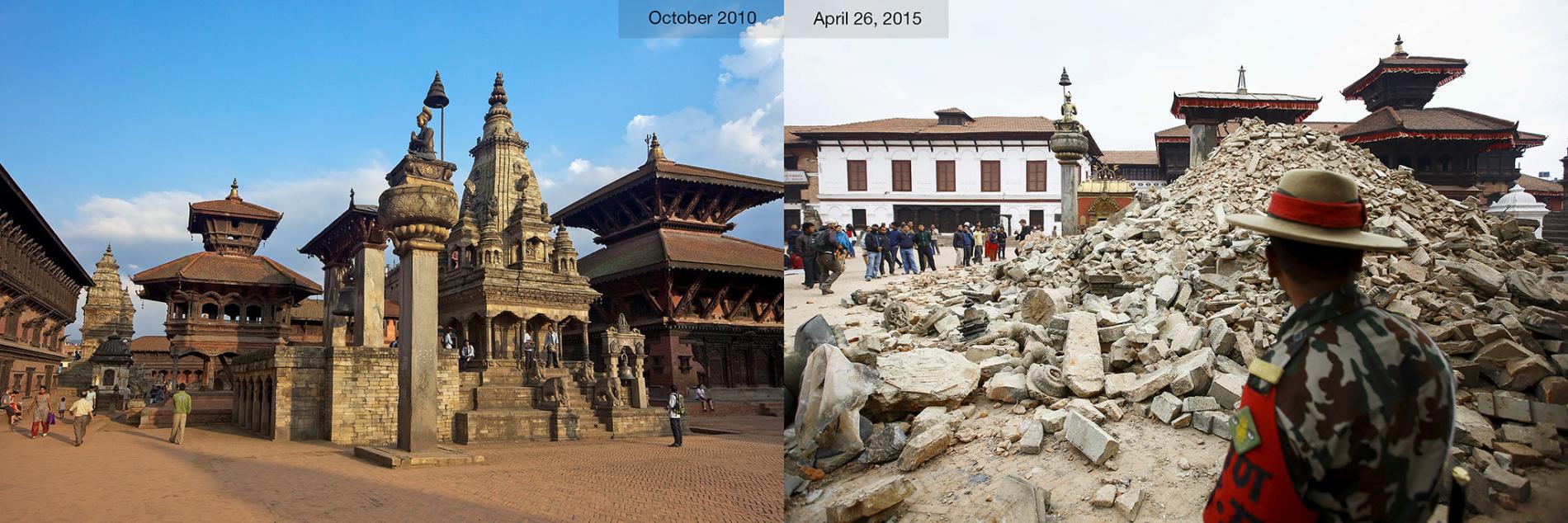
Figure 7. Destruction of ancient Hindu temples in Bhaktapur, Kathmandu valley, courtesy of National Geographic.
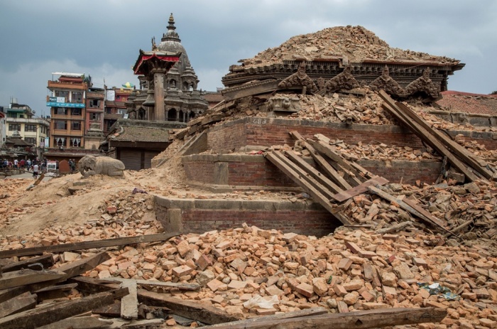
Figure 8. Ruined temples in Patan’s Durbar square near Kathmandu.
The Gorkha earthquake was the most recent in a long history of earthquakes along the Himalaya. From the collision of India with Asia and the Tethys seaway in between 5o million years folding and thrusting along the Indian plate has resulted in crustal thickening. Approximately 80-200 km of shortening is recorded in the Tethyan sedimentary rocks of the northern Tethyan Himalaya. Crustal thickening and buying of rocks to kyanite grade pressures (10-12 kbar; 35 km depth) occurred between ~35-30 Ma and decompression to sillimanite grade followed during the Miocene (~25-18 Ma). During this time the Main Central Thrust (MCT) along the base of the Greater Himalaya Sequence (GHS) was active simultaneously as the South Tibetan Detachment (STD) low-angle normal fault along the top. Following exhumation and cooling of the GHS thrusting propagated in-sequence down-section towards the south with to the Munsiari Thrust and Ramgarh thrust. The Kathmandu klippe is a remnant klippen of GHS rocks preserved above the Lesser Himalaya. About 10 million years ago the Main Boundary Thrust (MBT) became active along the southern margin of the Himalaya bringing Lesser Himalayan rocks southwards over Siwalik foreland sediments of the Ganga foreland basin. The active thrust is the Main Frontal thrust (MFT) that is presently a blind thrust imaged beneath the gentle folds of the Siwalik hills. All these Himalayan thrust faults root into a major detachment called the Main Himalayan Thrust (MHT) that represents the present day plate margin, where India is underthrusting the Himalaya.
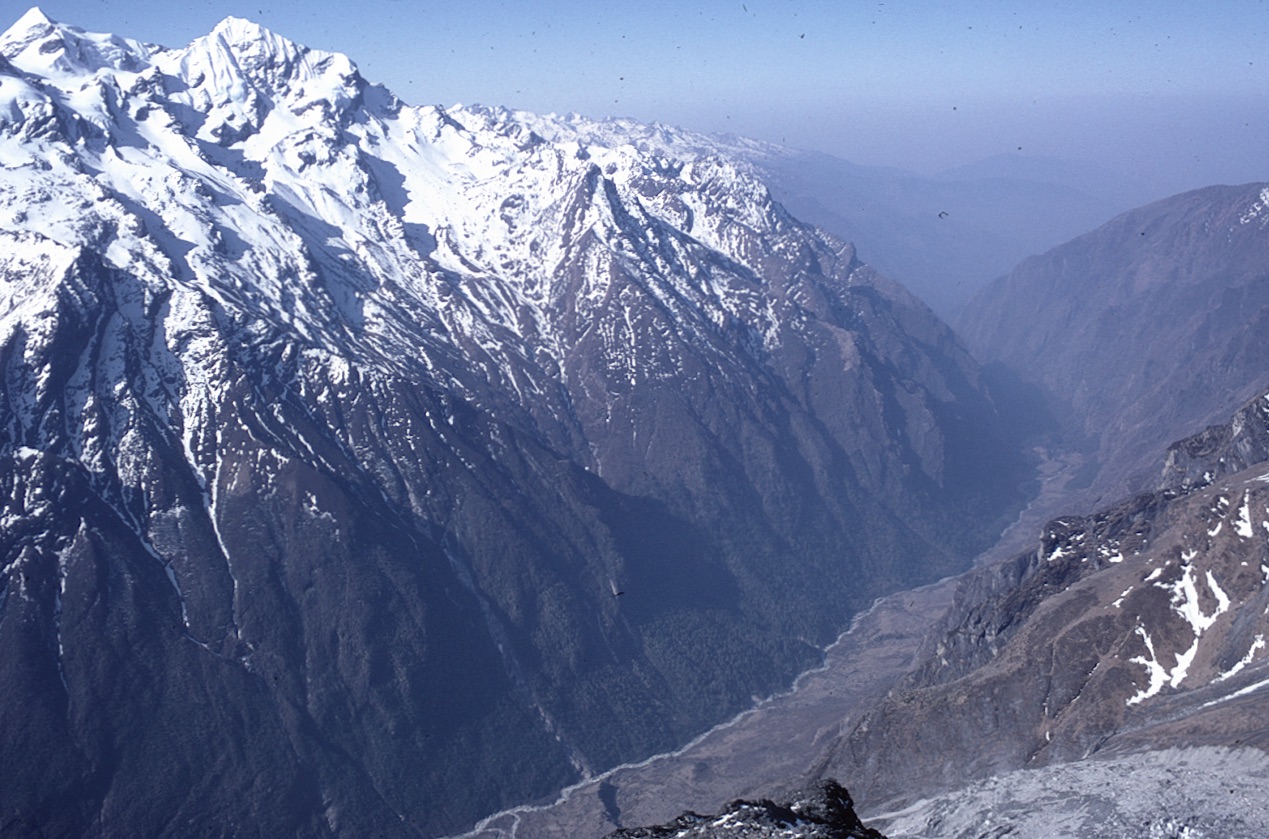
Figure 9. View down the South face of Langtang Lirung looking straight down the avalanche tract prior to the earthquake (photo Mike Searle).
Seismologists and geodesists have long predicted that the MHT could rupture along this part of the Himalaya. Global Position System data shows that convergence between India and South Tibet occurs at a rate of 17.8 ± 0.5 mm/year in central and east Nepal and 20.5 mm/year in western Nepal (Bilham et al. 1997; Ader et al., 2012). The last major earthquake along the Himalayan front was the 1934 Bihar – Nepal of magnitude 8.1 which destroyed much of Kathmandu. The largest known Himalayan earthquake was the 1950 Assam earthquake of Mw ~8.6 which occurred on a right-lateral strike-slip fault. In western Nepal the 1505 earthquake ruptured the far west of Nepal segment but central Nepal, centred on Kathmandu, was in a seismic strain shadow where an earthquake was expected. Of course the timing of the earthquake cannot be predicted. In the western Himalaya the Mw 7.6 Kashmir earthquake occurred on the same Main Boundary Thrust (MBT) fault near Muzaffarabad close to the India-Pakistan border region of Kashmir.
The most worrying factor is that the Nepal or Gorkha earthquake did not cause a surface rupture and thus the strain built up remains at depth. The likelihood of another earthquake is great, either to the south of Kathmandu where the Main Boundary Thrust reaches the surface, and/or to the west of the epicenter, west of Gorkha where the fault did not rupture and remains locked.
Nepal is in urgent need of aid from around the World. Donations can be made to Community Action Nepal (CAN) at www.canepal.org.uk
References
![]() This work is licensed under a Creative Commons Attribution-NonCommercial-ShareAlike 4.0 International License.
This work is licensed under a Creative Commons Attribution-NonCommercial-ShareAlike 4.0 International License.