Richard Bates is a Senior Lecturer at the University of St Andrews. See his website here.
Operation Iceberg – Mapping the Changing face of Arctic Ice
Over the past 5 years I have found my summers occupied by research expeditions to the Arctic. The projects began in 2009 with a request from colleagues at the Centre for Glaciology, Aberystwyth University to support a cruise aboard Greenpeace’s RV Arctic Sunrise to the Petermann Glacier on the north coast of Greenland. At 81degree north The Petermann is a 15km wide, 60km long marine terminating tongue of ice that drains a significant portion of the Greenland ice sheet. The glacier has a history of large calving events and we were there to record, and ultimately try to understand, the drivers to calving. The first year there were no large events but we got the chance to test a range of geophysical methodologies that we were then able to apply over the next few years at other calving glaciers. The methods including instrumenting the glacier with arrays of GPS to record the speed and deformation of the ice, deploying pairs of time-lapse cameras on the surrounding rock walls to record surface motion and deformation (this was part of the highly successful global effort to record changing glacial conditions, see the Extreme Ice Survey), using multibeam sonar at the terminating end to record the dynamics of ice calving and melt, measuring temperature, salinity, turbidity at the melt front and in moulins (holes) through the glacier. One of the more adventurous geophysical methods involved using ground penetrating radar mounted in kayaks to record the glacier thickness while paddling down one of the major melt rivers that drain the surface (see more photos here). The major hazard here was not the near freezing water, rather making sure we got off the water before it descending via a whirlpool through the glacier.
 |
|
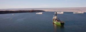
Greenpeace Arctic Sunrise at the Petermann Glacier
|
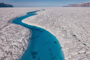 |
| Kayaking down the Petermann Glacier making radar measurements of ice thickness |
In 2010 and again in 2012 the Petermann (article from the Earth Observatory) did calve with major ice island formed that gradually worked their way south out into Baffin Bay over the next couple of years. One of the major islands formed part of a later study partially funded by the BBC for their Operation Iceberg TV documentary. Our research projects that were covered by the documentary included using the multibeam sonar to make time-lapse measurements at two glaciers on the west coast of Greenland, namely Store and Lille Glaciers. Store is one of the largest and most dramatic of the surging glaciers on the west coast with a calving front over 4km wide and 1km tall (submerged and above water component). Here the calving occurs as dramatic and sudden events with bergs that both fall off and erupt from the glacier front. Recording these events had its moments and you certainly needed to time the science between events not to be anywhere within a km of the calving when it took place. Luckily our research boat, Gambo (a 15m steel hull yacht is quite manoeuvrable!).
 |
| Gambo surveying at front of Store Glacier |
The second episode of Operation Iceberg followed the ice islands that had broken off the Petermann Glacier as they drifted south along the Baffin (Canadian) coastline. The islands provided a perfect refuge for the region’s most iconic wildlife, the polar bears, to the point that working on the islands became somewhat difficult. Still, this allowed me to make measurements of not only the calving/melting sides beneath the water but also to simultaneously measure the above water side using laser scanners. This data is allowing new mathematical models of the breaking mechanisms to be formulated – more on this from colleagues in Cambridge and California in future blogs.
The more I travel up north I realise that the Arctic is a rapidly changing environment. Much is made of these changes in the press with links to climate variations and human driven acceleration of climate change as the major issue. You only have to visit these vulnerable areas once to see the impacts and I urge you all to do so.
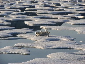 |
| Polar bear resident of the calved Petermann ice island |
)
![]() This work is licensed under a Creative Commons Attribution-NonCommercial-ShareAlike 4.0 International License.
This work is licensed under a Creative Commons Attribution-NonCommercial-ShareAlike 4.0 International License.