 |
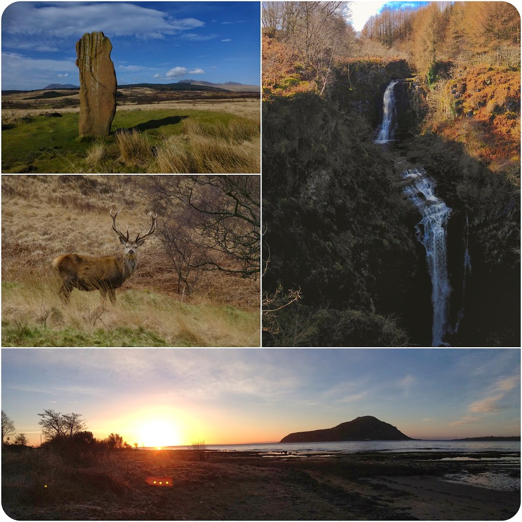
| Clockwise from upper left: Standing stone of Machrie Moor; falls of Glenashdale; sunrise looking towards Holy Isle; Red Deer stag in Glen Rosa. |
Along the northern coast of Arran near the village of Lochranza is a fantastic exposure of the North Sannox Grits (part of the Neoproterozoic Dalradian Supergroup). This formation contains a variety of lower greenschist-facies pelites, psammites, and pebble conglomerates and has been multiply deformed by the various phases of the Caledonide Orogeny. In most areas where the Dalradian is exposed it is intensely folded and steeply dipping.
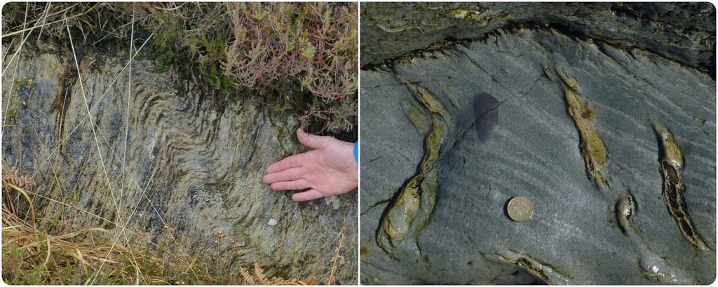 |
| Left: folding in the North Sannox pelites. Right: Quartz veins and crenulation cleavage in the North Sannox Grits. |
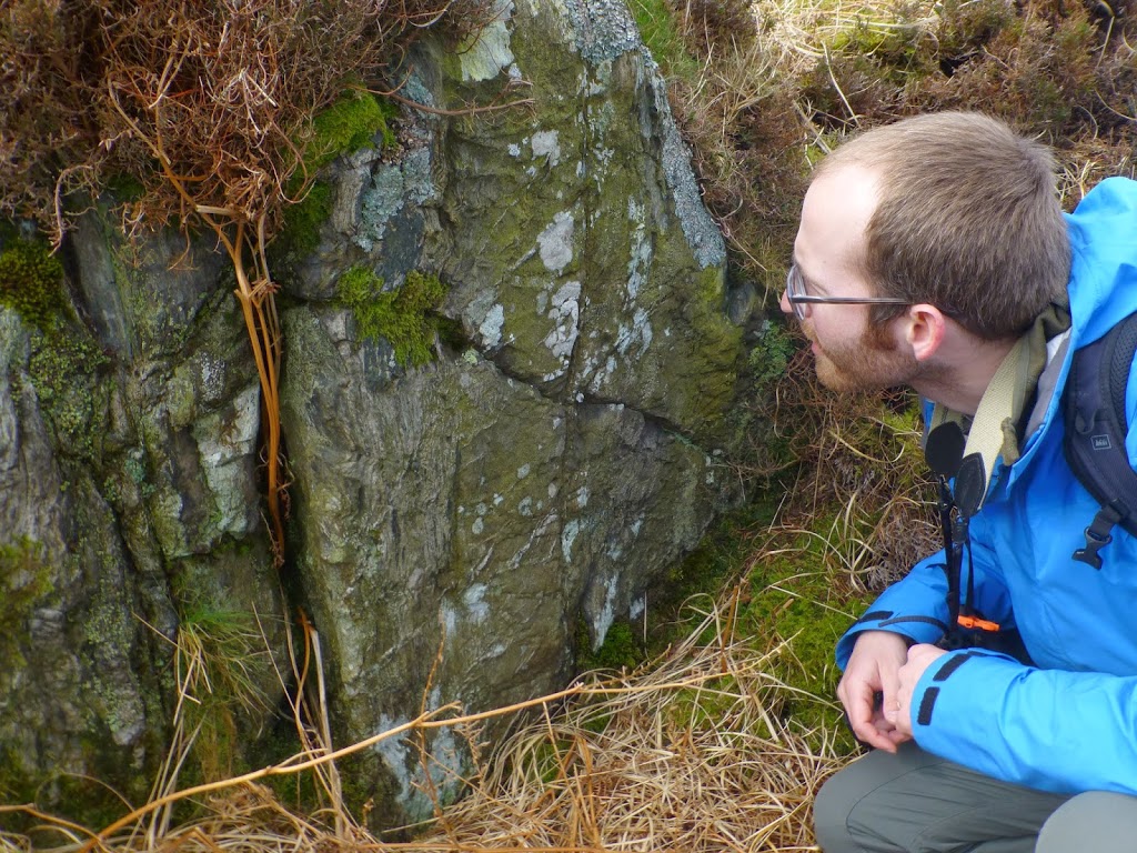 |
| Carl Hoiland examining strain partitioning in the North Sannox pelites and psammites. The pelites exhibit dense schistosity and asymmetric folds whereas the 15 cm psammite band in the center of the photograph is virtually undeformed aside from late stage veining. |
Near Newton Point along the coast is a 100 meters of outcrop of the Kinnesswood Formation which formed the upper portion of the Old Red Sandstone. The Kinnesswood Formation was deposited in the early Carboniferous period and is represented by medium- to coarse-grained red sandstone.
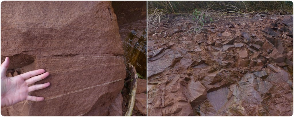 |
| The Kinnesswood Formation near Brodick. In most parts of Scotland the post-Caledonide sedimentary successions are relatively undeformed and shallowly dipping. |
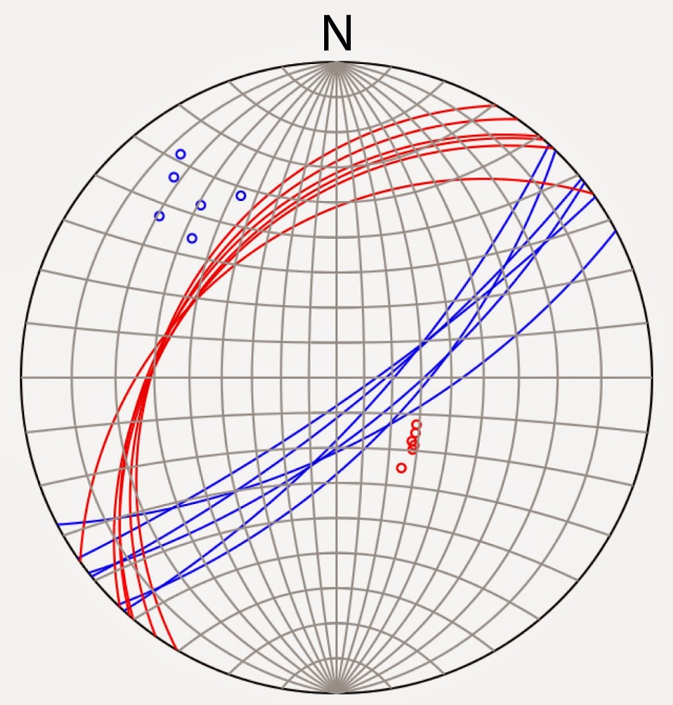 |
| Stereonet of Hutton’s Unconformity Red: “Old Red” Blue: Dalradian |
“I had long looked for the immediate junction of the secondary or low country strata with the alpine schistus, without finding it; the first place in which I observed it was at the north end of the island of Arran, at the mouth of Loch Ranza; it was upon the shore, where the inclined strata appeared bare, being; washed by the sea. It was but a very small part that I could see; but what appeared was most distinct. Here the schistus and the sandstone strata both rise inclined at an angle of about 45°; but these primary and secondary strata were inclined in almost opposite directions; and thus they met together like the two sides of a λ, or the rigging of a house, being a little in disorder at the angle of their junction. From this situation of those two different masses of strata, it is evidently impossible that either of them could have been formed originally in that position; therefore, I could not here learn in what state the schistus strata had been in when those of the sand-stone, &c, had been superinduced.” – Theory of the Earth, ch. 6, sec. 1
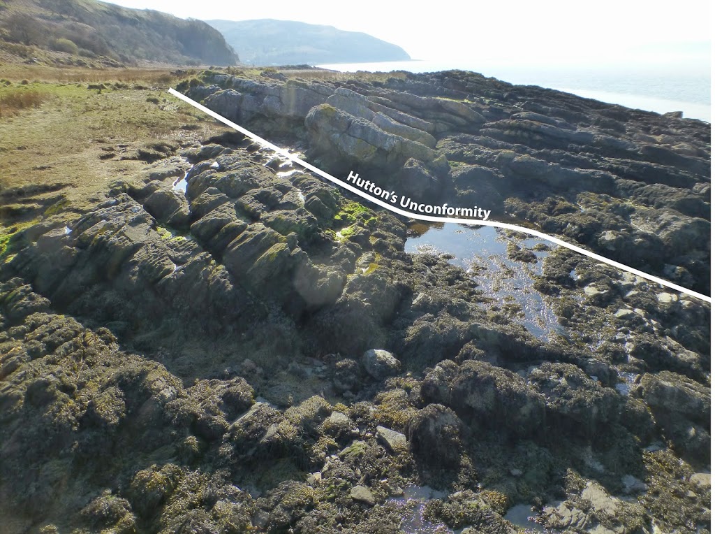 |
| Hutton’s Unconformity on the Isle of Arran with the Dalradian below and the Kinnesswood above. Looking SW towards Lochranza. |
| This is a Gigapan of Hutton’s Unconformity. Zoom around to see the Old Red Sandstone to the left and the Dalradian schists to the right. Can you find the geologist? |
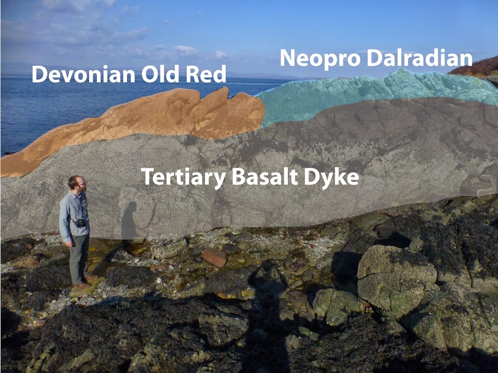 Additionally, there are a series of basaltic dykes (presumably Tertiary in age) that intrude through the unconformity.
Correction: the “Old Red” at this locality is actually Carboniferous (see BGS RR/01/04).
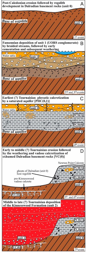 |
| Sequence of events from the Jutras et al. 2011 study published in Geology. |
Recently, the relationships of this classic localities were reassessed by a group of geologists at Saint Mary’s University and the University of Western Ontario (Jutras, Young, and Caldwell, 2011 Geology). These workers found evidence that this unconformity actually represents a double unconformity with two discrete erosive and depositional events. They propose that following the Neoproterozoic deposition and Ordovician deformation and metamorphism of the Dalradian Supergroup (unit 0), these basement rocks were deeply eroded and developed a thick layer of regolith (A in figure to the left). This was followed by the deposition of the lower to upper Devonian Old Red Sandstone (unit 1) which resulted in the variable cementation of the Dalradian regolith (B). These workers then propose that this deposition was followed by the calcretization and formation of a massive phreative calcrete hardpan of the previously exposed Dalradian regolith [PCH(0)] and the basal portion of the Old Red Sandstone [PCH(1)]. In the lower portion of this calcrete [PCH(0)], relict foliation of the Dalradian can be seen within the calcrete (photo below). This was followed by partial erosion of the Newton Point calcrete (D) and infilling from the deposition of the Kinnesswood Formation (unit 2). These new results further elucidate the complex processes involved with the formation of Hutton’s Unconformity. Before James Hutton, the origin of these rocks was explained by the Deluge. Hutton enhanced our understanding through an array of simple scientific principles. The beauty of this example is that it illustrates how despite the added level of detail in explaining the origin of these rocks, there are scientists over 200 years later who are still working on the same localities and are adding tremendous levels of detail to our understanding of Earth processes.
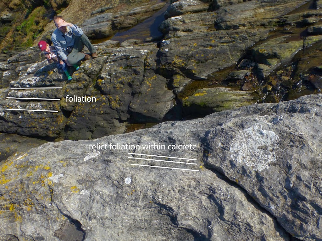 |
| Photo looking down at the Dalradian calcrete: PCH(0) onto the exposed Dalradian basement. Relict foliation (or “ghosts”) can be seen within the lower portion of the calcrete unit |
![]() This work is licensed under a Creative Commons Attribution-NonCommercial-ShareAlike 4.0 International License.
This work is licensed under a Creative Commons Attribution-NonCommercial-ShareAlike 4.0 International License.