It was one of those rare, shining moments of feeling instrumental – of making a connection between what we love doing and the needs of others. Such was the case on a Sunday afternoon, after church, in the village of Gelala on Ambon Island (Indonesia). Many centuries ago, Gelala was one of the most important places in the world because it was where nutmeg, cloves and other spices, only known from eastern Indonesia, were loaded onto ships bound for Europe. If the ships made it back, the spices were worth their weight in gold.
 |
|
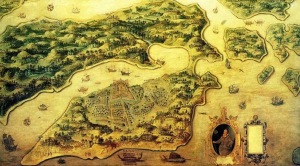
17th century map of Ambon Island and the Dutch Colony established for the spice trade. Gelala is located at the narrowest part of the bay to the right of the Fort.
|
 |
|
Left – Nutmeg and mace (the waxy red casing of the nut). Right – Cloves.
|
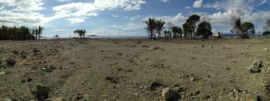
Gelala is also famous for the number of times it has been destroyed by earthquakes and tsunamis. The most recent event was on Sunday afternoon, the 8th of October 1950, after church.
“A call for help came from Ambon Island because of a strong earthquake magnitude 7.3 and a gigantic tidal wave. A large number of victims is feared. The existence of this great wave (according to press accounts, it had a height of 200 m) could not be confirmed from the tide gauge records.”
We found two men and one woman still living in the village who remembered the event. They all gave a similar story even though I interviewed them separately. They said that after a minute or so of strong shaking cries were heard throughout the village to run. A large wave was approaching and the people only had a few minuets to escape to the nearby hills. From the vantage point of the hill they watched the wave wipe out the village, leaving only one home standing. A Japanese metal ship was washed 200 meters inland and rested on the hill next to the only surviving home. Another survivor, who did not hear the cry to run because she was deaf, was swept by the tsunami into a tree that she climbed. The tree is 8 meters tall; the base is 2 meters above sea level. One of the eyewitnesses, Esther Pung (see below) showed us the ruins of the home she lived in at time. It, like all of the other homes in the city, was sheared from its foundations by the wave.
 |
|
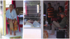
Oma Esther Pung (left) who was 15 when she witnessed the 1950 earthquake and tsunami. (Right) My interview of Esther about what happened. The village leader or Raja (stripped shirt) and many others helped me with the translation from the local language.
|
 |
|
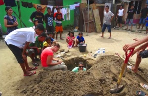
Professor Nicole Cox (green shirt) and geologist Rachel Dunn (red shirt) logging a trench dug in the heart of Gelala Village.
|
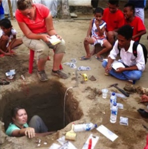 |
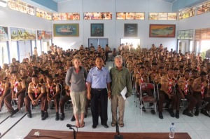
| A reporter from the Ambon Ekspres (white shirt) observes the trenching investigation for tsunami deposits in Gelala. The article he published a few days later resulted in an emergency meeting of the Governor and his staff, and made the national news. Most of the people in Gelala and the Ambon region were unaware of the earthquake and tsunami hazards they face. Now they know, and they are conducting evacuation drills to prepare. |
We interrupted the investigation for a few hours in order to make a presentation about tsunami hazards at one of the local churches. There was standing room only for the presentation. The word was spreading about our forecast of future earthquakes and tsunamis; many wanted to hear it for themselves. After the presentation we were inundated with people asking when these things would happen. Even though we explained clearly that ‘when’ is unknowable they still pressed us for some kind of prediction.
One of those in crowd was a reporter for the Ambon Ekspres, the newspaper for the region. I apologized that we did not have time at that moment for a full interview, but if he came with us to Gelala he could hear the accounts of eyewitnesses and see for himself the layers of destruction Rachel and Nicole were excavating. On the way back to the excavation site I showed him the catalog of natural disasters we had compiled for the region. One of my former students had translated it into Indonesian. It documents how Ambon was flattened four times by earthquakes and inundated 5 times by tsunamis in the past 400 years.
Why Indonesia?
This rare moment of communicating directly and effectively with those in harms way was beauty from ashes. The people of the Indonesian region have suffered huge losses from natural hazards, as much or more than any other place on Earth. Yet, only until recently have they been able to understand these hazards in way that informs them how to protect themselves.
My small roll in this effort to communicate and empower those in harms way of natural hazards in Indonesia started without me knowing during my first scientific expedition to Indonesia in 1987. While there I learned the language and lived among the local people, which endeared my heart to them and the enchanted islands they inhabit. What initially brought me to Indonesia is my interest in what happens when tectonic plates collide, which Indonesia showcases like no other place on the planet. It is an ative tectonic maelstrom. What brings me back to Indonesia now is how to help people protect themselves from the natural hazards associated with plate collisions.
The transition from my purely academic interest to a more humanitarian focus was initiated by a desire to share Indonesia with my family, so they could better understand what I did when I left them for months to do research there. One day I overheard my son explain to a friend that his dad, “is a ‘doctor’, but not the kind that helps people.“
My sons comment caused me to reflect upon the underlying intent of the passion I felt for my research. The disconnect between my academic research and the basic needs of others that was so obvious to my son was real, and soon became obvious to me as well.
Within a few months of my sons comment I had crafted a proposal identifying a whole new direction of geological research that, even to this day, has few practitioners. It is called natural hazard forecasting. Indonesia is the ideal testing grounds to see if hazardous geophysical events can be forecast and thus lives saved. What I did not appreciate at the time I wrote the proposal is that the second part of the previous statement does not necessarily follow the first part.
My proposal was funded by the US Department of State through a Fulbright Research Fellowship to Indonesia. This fellowship also provided funds for my family to travel with me and hopefully see for themselves how the geological sciences may directly help those in harms way.
A Year of Living Dangerously
My first glimpse of the scale of the problem of natural disasters in Indonesia came as my Indonesian colleagues, many students and I conducted geological investigations and compiled historical records of what had happened there in the past. Over the past 25 years we have completed 18 extensive expeditions to various parts of Indonesia and translated hundreds of records kept mostly by Dutch colonists of the major earthquakes and tsunamis in Indonesia as far back as the 16th century. We found evidence of more than 1000 earthquakes, 115 of which were destructive, and at least 90 tsunamis between 1600 and 1950. Many of the earthquakes left the fledgling cities of the time in ‘rubble heaps’ multiple times. Several tsunamis are recorded with run-up heights > 15 meters, with some greater than 100 m. Many islands were engulfed and coastal communities washed away.
The research resulted in two publications that forecast what was likely to happen in the future and where. The first paper was published in 1997 in Indonesian and the second in 2002 in English. Historical records indicated that the Sumatran region was one of the most likely places for large (magnitude 8+) earthquakes and tsunamis. We also warned of hazardous regions in central Java where smaller, more frequent earthquakes occur and are commonly followed by devastating volcanic eruptions. We specifically warned of the dire consequences of a major eruption of Merapi volcano near Yogyakarta, based on archeological data we investigated while living there.
When major earthquakes and tsunamis, and even major eruptions, will happen is unknowable. However, the historical record provides details over a large enough time window to recognize where these events were likely to reoccur. In other words, we thought we could address the question of ‘Who’s Next?, which was the title of the 2002 publication.
 |
|
Paper published in 2002 forecasting the likely recurrence of major earthquakes and tsunami in Sumatra and other parts of Indonesia Carolus Prasetyadi, who is one of my former graduate students and now a professor at UPN, is the co- author. A earlier version of the paper was published in Indonesian in 1997.
|
The Beginning of the Earthquake Storm
Two years after the publication, in November of 2004, I was giving a talk about our forecasts at a university in Dili, the capital of East Timor, which is one the places we warned about in the papers. During the talk I mentioned that, based on what we knew from historical accounts, enough tectonic strain energy had already accumulated in the Timor region to produce a magnitude 7 earthquake. I also mentioned that because most of the active faults in the region were underwater the earthquake would likely produce a tsunami. To demonstrate this I flicked a glass of water with my finger and noted that the earthquake would cause the ocean to slosh onto the land just like the water in the glass sloshed onto the podium. Few, if any, of those in attendance appeared to take me seriously.
The very next morning after the talk a magnitude 7.6 earthquake struck near Dili and caused a tsunami that flooded parts of the capital including the university where I gave the talk. When the earthquake hit I was bathing according to the local custom of scooping water out of a receptacle. Just as I was all lathered up, water began to slosh out of the container and the unreinforced masonry walls of the bathroom started moving in a wave-like motion. Fortunately, the building held and I survived the awkward situation.
This earthquake, however, was the beginning of a seismic storm that is still raging today in Indonesia. Within a few weeks of the Dili earthquake, a gigantic segment of the boundary between the Asian and Australian plates ruptured off the NW coast of Sumatra, where we had forecast it would happen. Pressure had been building along the plate boundary for hundreds of years without any large earthquakes, which is why we drew attention to it in our article.
“The most dangerous seismic gaps in Indonesia exist in populated regions of western Sumatra, south-central Java, and Timor… The entire sixteen hundred kilometer length of the Sumatra fault system has not slipped significantly for 130–150 years. Since this time, seven to eight meters of potential slip have accumulated and will most likely be released suddenly to produce a magnitude 8.0+ event …” (Harris and Prasetyadi, 2002).
 |
|
Left: Map of Sumatra and part of Java with the likely rupture areas of historical earthquakes between 1795 and 1994. Right: Same map with major earthquakes and volcanic eruptions that have happened since we published our paper in 1997. Nearly 50 years had passed without an earthquake > magnitude 8.0 anywhere on Earth. Since the 2004 magnitude 9.2 earthquake there have been 5 earthquakes > magnitude 8.0 in western Indonesian alone. A similar scenario occurred in the mid 1800’s throughout Indonesia.
|
 |
|
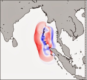
Computer simulation of the 2004 South Asian Tsunami about
1 hour after the magnitude 9.3 earthquake. The red areas are positive waves and the blue areas are negative waves (sea withdrawal). The first positive waves struck Banda Arc within 30 minutes of the earthquake. Whereas, it took 3 hours for the waves to reach Thailand to the east and 4 hours to reach India to the west. Still, no warnings were issued. |
The entire northern Sumatran and Andaman Islands part of the Asian Plate, which had been pushed eastward for hundreds of years, lurched back westward more than 20 meters at nearly the speed of sound. The sudden release of this much pint-up energy ruptured a 1600 km section of the plate boundary producing a magnitude 9.3 earthquake. This earthquake is the second largest ever recorded, which was much larger than we forecast. The rupture started near the NW part of Sumatra and propagated northward at around 3 km/sec all the way to the western shores of Burma. Even at this speed it took 9 minutes for the rupture to make the 1600 km journey. The shaking was so intense in the region that no one could stand. Many wondered if the world was coming to an end.
Lessons Learned from the 2004 Event
Immediately after the epic 2004 earthquake and tsunami the press jumped on the story that scientists had ‘predicted’ the event and no one listened to the warnings. Someone was to blame and it had to be the poor people of Indonesia. I was interviewed several times on television, radio and for newspaper articles. One time cameras and reporters from NBC, ABC and FOX were all set up at the same time in the conference room of the Geology Department at BYU. Instead of the story they were hoping to broadcast about how cleaver I was, what they got was a teary-eyed confession of the truth – that it did not matter how good our forecast was or where it was published. Those in harms way had no idea what was going to happen or how to respond. We left the communication and implementation to ‘someone’ else. Now we all know that the ‘someone else’ is us. We failed!
I suffered with battles of depression for several years after the tragic events of 2004. Eventually, I got back on my feet and started a non-profit organization called In Harms Way. The purpose is simple in concept – to communicate what natural hazards are likely to happen to those in harms way, but more important, do what did not happen before the 2004 disaster – go from village to village and make sure those in harms way know the dangers they face and how to protect themselves. We have not stopped our forecasting research, but augmented it hazards education and implementation of disaster prevention activities. These three key elements of preparedness are required to save lives from natural hazards. Our focus has permanently changed from ‘prediction’ to preparedness.
Recurring Earthquake Storm
One of the most interesting discoveries of our research of historical earthquakes and tsunamis is how these events cluster in time and place. In other words, the rate of these events is not constant and the locations are not random. Various parts of the plate boundaries surrounding Indonesia would release accumulated energy in the form of several large earthquakes and volcanic eruptions then set quietly for 30-50 years before another burst of intense activity. The gigantic 2004 earthquake released so much pressure that it caused the whole region start shifting again.
- Three months after the 9.3 earthquake, the plate boundary segment immediately south of it ruptured to produce a magnitude 8.7 earthquake and large tsunami that claimed thousands of lives.
- A year later, in 2006, a mid-sized earthquake (M = 6.3) struck central Java, killing around 6000 and displaced nearly a half a million people. Eruptions of nearby Merapi volcano increased in frequency and intensity. What happened is nearly identical to what we found in historical records and warned would likely reoccur in central Java.
“The collisional plate boundary near densely populated Java has some of the highest strain rates in the world…which is manifest by more frequent moderate earthquake events (M 5.5–7.5)… Although these moderate events are of lesser magnitude…they pose a greater threat due to the more frequent devastation and disruption they inflict…Poorly regulated development in these zones of high seismic flux poses a significant threat not only to the many cities with unfavorable site characteristics, but also densely populated rural regions that have rapidly expanded into seismically unstable hillsides and cities along shorelines vulnerable to tsunami destruction. Most buildings in these regions are incapable of withstanding even mild horizontal ground motions…As witnessed in recent moderate seismic events … a magnitude 6.4 quake near densely-populated regions with weak dwellings can cause thousands of deaths, billions of dollars of damage, sever gas and water lines, damage critical facilities … and cause sudden economic collapse. These types of damage initiate new disasters” (Harris and Prasetyadi, 2002).
- Two months after the seismic disaster in densely populated Yogyakarta, a magnitude 7.7 earthquake struck off the coast of central Java causing a large tsunami killing hundreds of people.
- In 2007 a magnitude 7.5 earthquake struck near Jakarta, a city of around 15 million people. Fortunately, the earthquake was 280 km deep and resulted in little damage.
- Two months later a series of earthquakes, including a magnitude 8.5, 7.9 and 7.1, struck the SW coast of Sumatra within 24 hours of one another causing more fatalities.
- In 2008 there were three earthquakes between magnitude 7.0-7.5 that caused fatalities in the region.
- In 2009 there were four destructive earthquakes between magnitude 7.0 and 7.9 that accounted for more than 2500 fatalities in Sumatra.
- In 2010 there were three more earthquakes between magnitude 7.2 and 7.9 that accounted for hundreds of fatalities. A few hours before the 7.9 event Merapi volcano in central Java exploded with an intensity that had not happened since 1870. Hundreds of fatalities resulted, but it could have been much worse, as close to 350,000 people were evacuated immediately before the eruption.
- In 2012 a magnitude 8.6 earthquake struck off the coast of northern Sumatra, which was followed two hours later by a magnitude 8.2 earthquake near the same location.
- In 2013 a moderate earthquake (M = 6.1) in northern Sumatra caused fatalities to keep the trend of earthquake-related fatalities going yet another year.
Before the gigantic 2004 earthquake there had not been a seismic event anywhere on the planet greater than magnitude 8.5 for nearly 39 years. Within the next 7 years, 4 earthquakes larger than 8.5 happened in western Indonesia alone. It has been a decade of utter seismic terror, and more is likely to happen before the seismic cluster ends.
More troubling, is the greater rate of fatalities than in the past. Indonesia has had earthquake fatalities in 25 of the past 26 years. Before this the record was only two consecutive years.
Prevention Pays Off
If the earthquake storm in Indonesia was not enough, on 3/11/11, there was a replay of what happened in Indonesia in 2004, only this time it happened in prevention minded Japan. Even though the size of the earthquake and tsunami in Japan was comparable to the 2004 event in Indonesia, and the population density nearly the same, one person died in Japan for every 10 who died in Indonesia. Preparedness saved thousands of lives in Japan. Tsunami is a Japanese word, and the people of Japan are well aware of what it is and how to respond. Tsunami evacuation sites are common, and most people in coastal communities had participated in tsunami evacuation drills before the 2011 event.
Indonesia’s Next Generation
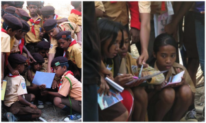
Indonesia has a mandatory scouting program called Pramuka that involves boys and girls. Their scout motto is ‘Siap dan Waspata’, which means ‘readiness and awareness’. In 2008 Carolus Prasetyadi, one of the Indonesian geology professors of the WAVES team, and I were successful in linking our disaster mitigation activities with Pramuka. Since then we have made numerous presentations to groups of scouts and their leaders in many of the islands of Indonesia. On some islands a special scout jamboree was held for the purpose of helping the scouts make a hazard map of their own island.
 |
|
Pramuka (boy and girl scouts) making geological hazards map of their island.
|
 |
|
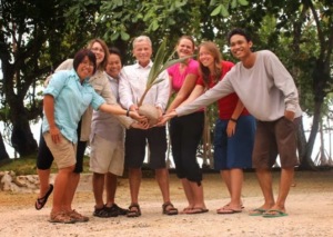
Waves team holding a sprouting coconut, which is the symbol of Pramuka: the new growing out of the old. From right to left: Nova Roosmawati, Nicole Cox, Hendro Nugroho, Ron Harris, Rachel Dunn, Talia Klein and Hanif ibadurrahman.
|
 |
|
Auditorium filled to capacity with Pramuka in uniform at one of the natural disaster prevention training jamborees held at the School for Mariners. Volunteer geologist Rachel Dunn stands to the left of the head master and me to the right.
|
We stayed in contact with Juliana by email after we left Ambon. She shared with me many success stories about her teaching preparedness and prevention at schools, churches and other public meetings. She gave more than 40 presentations throughout the community, including 10 presentations at various universities in Ambon.
When I met Juliana in November of 2013 she was accompanied by a disaster prevention team she assembled for Ambon. The team consists of the resident geophysicist from the Geophysical Survey of Indonesia (forecasting), the head of the Office for Social and Cultural Affairs for the island (communication), the head of the Red Cross and the regional head of the Civil Defense Agency (Implementation).
Tears welled up in my eyes as I begin to understand the impact of that simple meeting in 2012 where we mentored Juliana. When the WAVES team arrived in Ambon in 2013, Juliana had several speaking and training engagements set up for us for us. At the first presentation Juliana told an amazing account about a disaster averted due to her vigilance with implementing disaster prevention strategies.
 |
|
Ambon Disaster Mitigation Team. Back row: Julian and the head of the Red Cross. Front from left to right: Civil Defense leader, Head of Disaster Management, me and Geophysicist from Indonesian Geophysical Survey.
|
We visited the site of the disaster and the large refuge camps adjacent to where the city used to be. Rachel Dunn, one of the volunteer geologists of the WAVES Team, made the comment that all of these people owe their lives to Julian and her commitment to disaster prevention. We interviewed many of the people in the tents of the refuge camp and they confirmed that it was Julian’s vision and vigilance that saved the people of Negri Lima.
 |
|
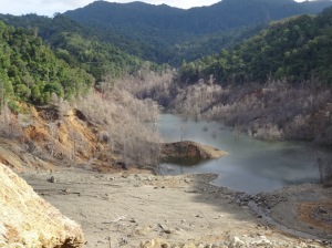
Dead jungle caused by the lake that formed behind the landslide.
|
 |
|
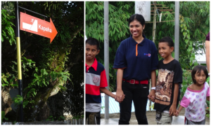
Left – evacuation sign designed by Juliana that guided the successful evacuation of more than 2500 people out of harms way in Negri Lima. Right – Juliana with some of the children she saved. It is not obvious, but Juliana has tears running down her cheeks because just before taking this photo I told here that we would find funds to help her conduct more evacuation drills in cities on her island that are threatened by floods and tsunamis.
|
 |
|
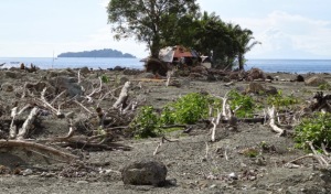
Overlooking the site where the city of Negri Lima used to reside before it was totally destroyed by the 30 July 2013 flood.
|
 |
|
Detail of photo above taken near the one house left of the 425 destroyed by the Negri Lima flood. The house was torn from its foundation and jammed in between two trees, which prevented it from being washed into the sea like the rest of the city. Notice downed tress in foreground.
|
![]() This work is licensed under a Creative Commons Attribution-NonCommercial-ShareAlike 4.0 International License.
This work is licensed under a Creative Commons Attribution-NonCommercial-ShareAlike 4.0 International License.