By Adam McKean – Mapping Geologist with the Utah Geological Survey Geologic Hazards Program
Urban geologic mapping may sound like a mapping geologist’s nightmare with all the private property, disturbed land, and development rapidly covering up the geology. Despite these difficulties, my experience with it has been exciting and challenging. Why map geology in and near the city? The simple answer is that urban areas need surficial geologic maps to aid in geologic-hazard identification and mitigation. Additionally, a good geologic map provides the basic geologic information needed for further geologic, groundwater, geotechnical, and engineering investigations.
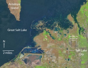
While mapping the geology between Salt Lake City, Great Salt Lake, and Antelope Island, I have come across a number of interesting alluvial, deltaic, and lacustrine (lake) deposits and geomorphic features. The preliminary map of this area (McKean and Hylland, 2013) and the research of others (Currey and others, 1988; Murchison, 1989) suggest a history of migrating post-Lake Bonneville rivers and deltas.
 |
|
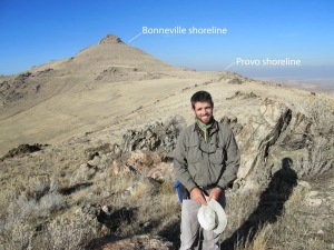
Figure 1.Field checking geologic units on the south end of Antelope Island. Late Pleistocene Lake Bonneville lacustrine gravels partially concealing the Early Proterozoic Farmington Canyon Complex gneiss, amphibolite, and schist metamorphic units. The upper shoreline notch in the photograph is the transgressive Bonneville highstand shoreline, the lower more prominent notch and bench is the regressive Provo highstand shoreline. Antelope Island is the largest island in Great Salt Lake, and the northwestern-most extent of our study area (see figure 2).
|
Surficial geologic deposits across most of my mapping area consist of lacustrine and deltaic deposits of late Pleistocene Lake Bonneville (30 to 12 ka), the Gilbert-episode lake (~11.6 ka), and Holocene Great Salt Lake (since ~11 ka) (Miller, 1980; Currey and others, 1988; Murchison, 1989; Oviatt and others, 1992).
 |
|
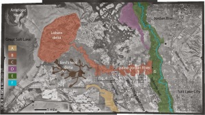
Figure 2. Mosaic of 1953 AMS black and white aerial photographs of Great Salt Lake, Salt Lake City, and the southern tip of Antelope Island. Highlighted areas show a simplified representation of post-Lake Bonneville alluvial channels and deltaic deposits. A) Gilbert-episode alluvial channel and delta deposited as the lake receded, B) post-Gilbert west-flowing paleo-Jordan River and associated lobate delta, C) bird’s foot delta that was deposited during the late Holocene highstand of Great Salt Lake, D) delta deposited during northward flow of the Jordan River, E) approximate location of Jordan River meander floodplain, F) modern modified channel of the Jordan River, G) location of 1997 paleoseismic trench on the Taylorsville fault.
|
Following the regression of Lake Bonneville, water flowing north along the valley floor entered the Gilbert-episode lake at the southern margin of my study area, and deposited stream and delta sediments (A in figure 2). Following the withdrawal of the Gilbert lake, the paleo-Jordan River incised into the lacustrine deposits of the previous larger and deeper lakes (B in figure 2). At the mouth of the paleo-Jordan River, a lobate delta developed along the Holocene Great Salt Lake margin. During the late Holocene highstand (4800-2100 years ago, calendar-calibrated years B.P. from Miller and others, 2005), Great Salt Lake flooded the valley to an elevation of about 4217 to 4221 feet. In the shallow water of the alluvial floodplain and older lacustrine deposits, a small bird’s foot-style delta developed to the south of the river channel (C in figure 2).
 |
|
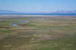
Figure 3.2013 oblique aerial photograph of a flooded late Holocene bird’s foot-style delta distributary channel on a flat-lying lacustrine and alluvial plain, view is to the west.
|
Sometime after the late Holocene highstand, both deltas and the paleo-Jordan River channel were abandoned. The Jordan River shifted to the north and now flows into Great Salt Lake through Farmington Bay (D, E, and F in figure 2). Displacement on the Holocene-active Granger, Taylorsville, and Warm Springs faults may have influenced the channel and delta shift.
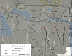
The Granger fault strand of the West Valley fault zone is truncated by the incised paleo-Jordan River channel (unit Qaly) (figure 4). A recent paleoseismic investigation of the West Valley fault zone across two strands of the Granger fault documented four large (surface-faulting) earthquakes since the highstand of Lake Bonneville (~18 ka) with the most recent occurring about 5500 years ago (DuRoss and Hylland, 2012; Hylland and others, in review). The paleo-Jordan River has eroded through the earthquake fault scarp since this most recent earthquake event.
 |
|
Figure 4.Location of paleoseismic trenches across the Granger fault strands shown in red (DuRoss and Hylland, 2012), geology of the Baileys Lake quadrangle (McKean and Hylland, 2013) draped over 2011 1m LiDAR hill shade (LiDAR available from OpenTopography, 2011), see figure 2 for location.
|
Near the east end of the incised paleo-Jordan River channel, two organic-rich samples (one of the samples was a scarp-derived colluvium) having an average age of 2200 years (Solomon, 1998) were collected from a 1997 consultant’s paleoseismic trench on the Taylorsville fault strand of the West Valley fault zone near Interstate-215 (G in figure 2). The 2200-year age was interpreted as approximating the time of a surface-faulting earthquake. My working hypothesis is that the 2200-year earthquake may have disrupted flow of the paleo-Jordan River, dropping the eastern margin of the river down to the east and potentially causing the Jordan River to shift and flow north instead of west (E in figure 2). The abandonment of the east-west flowing paleo-Jordan River may have also been influenced by earthquakes on the Warm Springs fault (figure 2) by tectonically lowering its base level. A small delta near the north end (D in figure 2) of the study area may represent a limited time of deposition before the Jordan River shifted to its current position (E and F in figure 2). However, not enough research has been completed in this area to determine its age or timing. The current channel of the Jordan River lies within its floodplain (E in figure 2), but has been modified to alter its natural path (F in figure 2).
Great Salt Lake levels that in part contributed to the multiple migrating deltas and river channels continue to fluctuate in response to climate cycles, water usage, and evaporation rate. The historic average lake elevation is about 4200 feet. In 1873 and 1987, Great Salt Lake rose to its historic high of 4212 feet (1284 m) (figure 5). Mapping of the historic high shows the potential for damaging flooding and shallow groundwater rise in the area adjacent to the lake.
 |
|
Figure 5.Cropped Landsat 5 “natural color” image of the flooding that occurred during the 1987 historic highstand of Great Salt Lake, image date June 2, 1987.
|
Through future mapping and study of this area, I hope to learn more about the post-Lake Bonneville geologic history of the Salt Lake region and potentially find more evidence to refine our understanding of our Salt Lake City backyard.
References
Currey, D.R., Berry, M.S., Douglass, G.E., Merola, J.A., Murchison, S.B., Ridd, M.K., Atwood, G., Bills, B.G., and Lambrechts, J.R., 1988, The highest Holocene stage of Great Salt Lake, Utah: Geological Society of America Abstracts with Programs, v. 20, no. 6, p. 411.
DuRoss, C.B., and Hylland, M.D., 2012, Paleoseismic investigation to compare surface faulting chronologies of the West Valley fault zone and Salt Lake City segment of the Wasatch fault zone, Salt Lake County, Utah: Final technical report to the U.S. Geological Survey, National Earthquake Hazards Reduction Program, award no. G10AP00068, 61 p., 2 plates, available online, http://earthquake.usgs.gov/research/external/reports/G10AP00068.pdf.
Hylland, M.D., DuRoss, C.B., McDonald, G.N., Olig, S.S., Oviatt, C.G., Mahan, S.A., Crone, A.J., and Personius, S.F., in press, Late Quaternary paleoseismology of the West Valley fault zone—insights from the Baileys Lake trench site, in DuRoss, C.B., and Hylland, M.D., Evaluating surface faulting chronologies of graben-bounding faults in Salt Lake Valley, Utah—new paleoseismic data from the Salt Lake City segment of the Wasatch fault zone and the West Valley fault zone: Utah Geological Survey Special Study.
McKean, A.P., and Hylland, M.D., 2013, Interim geologic map of the Baileys Lake quadrangle, Salt Lake and Davis Counties, Utah: Utah Geological Survey Open-File Report 624, 18 p., 1 plate, scale 1:24,000, available online, http://geology.utah.gov/online/ofr/ofr-624.pdf.
Miller, D.M., Oviatt, C.G., Dudash, S.L., and McGeehin, J.P., 2005, Late Holocene highstands of Great Salt Lake at Locomotive Springs, Utah: Geological Society of America Abstracts with Programs, v. 37, no. 7, p. 335.
Miller, R.D., 1980, Surficial geologic map along part of the Wasatch Front, Salt Lake Valley, Utah: U.S. Geological Survey Miscellaneous Field Studies Map MF-1198, 13 p., scale 1:100,000, available online, http://ngmdb.usgs.gov/Prodesc/proddesc_6624.htm.
Murchison, S.B., 1989, Fluctuation history of Great Salt Lake, Utah, during the last 13,000 years: Salt Lake City, University of Utah, Ph.D. dissertation, 137 p.
OpenTopography, 2011, Utah Geological Survey LiDAR, U.S. Environmental Protection Agency, and Utah Division of Emergency Management, Floodplain Management Program acquired 1 meter LiDAR data: Online, http://opentopo.sdsc.edu/gridsphere/gridsphere?gs_action=lidarDataset&cid=geonlidarframeportlet&opentopoID=OTLAS.042013.26912.1.
Oviatt, C.G., Currey, D.R., and Sack, D., 1992, Radiocarbon chronology of Lake Bonneville, eastern Great Basin, USA: Palaeogeography, Palaeoclimatology, Palaeoecology, v. 99, p. 225-241.
Solomon, B.J., 1998, New evidence for the age of faulting on the West Valley fault zone: Utah Geological Survey, Survey Notes, v. 30, no. 3, p. 8 and 13, available online, http://geology.utah.gov/surveynotes/archives/snt30-3.pdf.
![]() This work is licensed under a Creative Commons Attribution-NonCommercial-ShareAlike 4.0 International License.
This work is licensed under a Creative Commons Attribution-NonCommercial-ShareAlike 4.0 International License.